|
Home
|

|
|
|
Exits 66-64A Local lanes only
|
|
|
EXIT 66
Hackensack
Little Ferry
Moonachie
Ridgefield Park
Fairleigh Dickinson University -
Metropolitan Campus
|

|
EXIT 66
Directions
HACKENSACK
 GOAT Climbing Gym, 1 1/4 miles north GOAT Climbing Gym, 1 1/4 miles north
 Hackensack Performing Arts Center, 1 mile north Hackensack Performing Arts Center, 1 mile north
LITTLE FERRY
 Brix City Brewing Co., 1 mile south Brix City Brewing Co., 1 mile south
|
|
EXIT 65
South Hackensack
Teterboro
Teterboro Airport
|

|
EXIT 65
Directions
SOUTH HACKENSACK
Urban Air Adventure Park, at exit
TETERBORO
 Aviation Hall of Fame of New Jersey, 1 1/2 miles south Aviation Hall of Fame of New Jersey, 1 1/2 miles south
|
|
EXIT 64B
Hackensack University
Medical Center
NJ 17 South
Carlstadt
East Rutherford
Hasbrouck Heights
Newark
Rutherford
Wood-Ridge
|
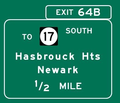
Continue south on 
|
|
|
EXIT 64A
Maywood
Paramus
Rochelle Park
|
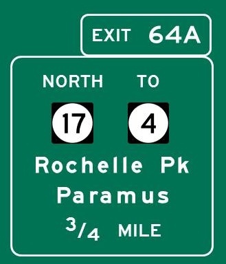
Continue north on
|
|
|
EXIT 63
Fair Lawn
Lodi
Rochelle Park
|

Continue north / south on
|
|
|
EXIT 62
Saddle Brook
Garden St Pkwy North
Exits 160-172
Hillsdale
Westwood
Garden St Pkwy South
Exits 157-0
Atlantic City
Cape May
Newark
Toms River
Woodbridge
|

Continue north / south on 
|
EXIT 62
Directions
MONTCLAIR
Montclair Art Museum, 11 miles SW
WEST ORANGE
 Edison National Historic Site, 17 miles south Edison National Historic Site, 17 miles south
|
|
EXIT 61
Co 507 North
Elmwood Park
Fair Lawn
Co 507 South
Garfield
Wallington
|

|
EXIT 61
Directions
FAIR LAWN
Garretson Forge & Farm, 1 1/2 miles north
|
|
EXIT 60
Hawthorne
Paterson - East Side/Riverside
Barnert Medical Arts Center
|

|
|
|
EXIT 59
Paterson - East Side/Lakeview
NJ 20 South
Clifton
Newark via NJ 21
Passaic via NJ 21
|

|
|
|
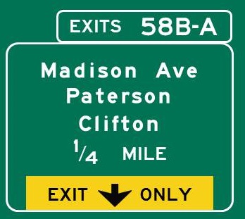
EXIT 58B
Paterson - Sandy Hill
EXIT 58A
Clifton
Paterson - South Paterson
St. Joseph's Regional
Medical Center
|
|
|
|
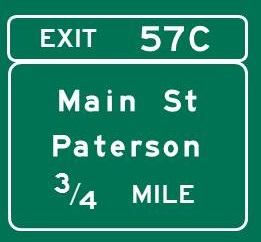
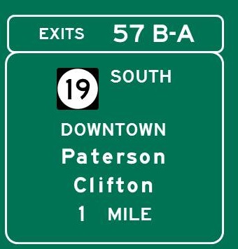
EXIT 57C
Paterson - Downtown
|
|
|
|
EXIT 57B
Paterson - Downtown
Passaic County Comm Coll
EXIT 57A
Clifton
|
|
EXIT 57B
Directions
PATERSON
Paterson Great Falls National Historical Park,
1/2 mile north
Paterson Museum, 1/2 mile north
PCCC Art Galleries, 1 mile north
EXIT 57A
Directions
LITTLE FALLS
Yogi Berra Museum and Learning Center, 3 miles SW
PATERSON
Lambert Castle, 3/4 mile south
|
|
EXIT 56
Paterson - Totowa/Hillcrest
Woodland Park
|

|
EXIT 56
Directions
WOODLAND PARK
 Garret Mountain Reservation, 1 1/4 miles east Garret Mountain Reservation, 1 1/4 miles east
Rifle Camp Park, 1 1/2 miles south
|
|
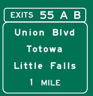
EXIT 55B
Totowa
William Paterson University
EXIT 55A
Little Falls
|
|
EXIT 55B
Directions
HALEDON
American Labor Museum/Botto House, 3 3/4 miles north
WAYNE
Dey Mansion, 1 3/4 miles NW
Shea Center for the Performing Arts, 4 1/2 miles north
William Paterson University Galleries, 4 1/2 miles north
|
|
EXIT 53
NJ 23 North
Butler
Franklin
Kinnelon
Pequannock
Wayne
NJ 23 South
Cedar Grove
Little Falls
Montclair
North Caldwell
Verona
US 46 West
Willowbrook Mall
|

Continue north / south on 
Continue east / west on 
|
EXIT 53
Directions
CALDWELL
Grover Cleveland Birthplace State Historic Site,
5 1/2 miles SW
FAIRFIELD
Claremont Distilled Spirits, 4 miles SW
Cricket Hill Brewery, 3 1/2 miles SW
Stumpy's Hatchet House, 2 miles SW
Tac Ops Laser Tag, 2 miles SW
VERONA
Kip's Castle Park, 4 3/4 miles south
WAYNE
DEFY Wayne, 1 1/4 miles south
Wayne Museum, 6 3/4 miles north
WEST ORANGE
Eagle Rock Reservation, 7 miles south
|
|
EXIT 52
Caldwell
Fairfield
Lincoln Park
West Caldwell
|

|
EXIT 52
Directions
FAIRFIELD
Funtime Junction, 3/4 mile SW
Jersey Artisan Distilling, 1 mile south
|
|
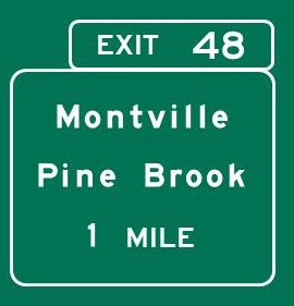
EXIT 48
Montville Township
Pine Brook
|
|
EXIT 48
Directions
FAIRFIELD
Jersey Spirits Distilling Co., 1 3/4 miles east
Magnify Brewing Co., 1 3/4 miles east
MONTVILLE
Sky Zone Trampoline Park, 1 mile SE
PARSIPPANY-TROY HILLS
Escaping Reality VR, 2 1/4 miles west
ROSELAND
 Essex County Environmental Education Center, Essex County Environmental Education Center,
3 3/4 miles south
|
|
EXIT 47
Lake Hiawatha
Parsippany-Troy Hills Township
Whippany
|

Continue west on
|
|
|
EXIT 43B
Boonton
Butler
Mahwah
Pompton Lakes
Wanaque
New York Thruway
EXIT 43A
Bernardsville
Bridgewater Township
Clinton via I-78 West
Hanover Township
Morristown
Phillipsburg via I-78 West
Somerville
|
Use local lanes at Milepost 46.3 for Exits 43A-B

Continue north / south on 
|
EXIT 43B
Directions
BOONTON
Boonton Historical Society and Museum, 3 miles north
Tourne County Park, 3 1/2 miles north
MONTVILLE
Montville Township Historical Museum, 6 miles north
Pyramid Mountain Natural Historic Area, 7 miles north
EXIT 43A
Directions
EAST HANOVER
The Funplex, 6 miles SE
MORRISTOWN
Morristown National Historical Park
Fort Nonsense, 7 1/2 miles SW
Jockey Hollow, 12 1/2 miles SW
Washington's Headquarters/Ford Mansion,
6 3/4 miles SW
PARSIPPANY-TROY HILLS
Stickley Museum at Craftsman Farms, 5 miles SW
RANDOLPH
Longo Planetarium, 10 3/4 miles west
Randolph Museum, 12 miles west
WHIPPANY
Whippany Railway Museum, 4 miles SE
|
|
EXIT 42B
Mountain Lakes
Parsippany-Troy Hills Twp
EXIT 42A
Morris Plains
Parsippany-Troy Hills Twp
|

Continue east / west on
Continue north / south on 
|
EXIT 42A
Directions
MORRIS PLAINS
Morris Plains Museum, 3 1/4 miles SW
|
|
EXIT 39
Denville
Tabor via NJ 53
|

Continue east on
|
|
|
EXIT 37
Co. Rt. 513 North
Hibernia
Rockaway Township
Co. Rt. 513 South
Rockaway Borough
|

|
EXIT 37
Directions
DENVILLE
Jonathan's Woods
Ford Rd. parking area, 1 1/2 miles NE
Old Beach Glen Rd. parking area, 2 1/2 miles NE
RANDOLPH
Fort Nonsense Brewing Co., 3 miles SW
ROCKAWAY BOROUGH
Bell & Barter Theatre, 1 mile SW
ROCKAWAY TOWNSHIP
Wildcat Ridge Wildlife Management Area
Hibernia Mines parking area, 3 miles north
Trailhead parking area, 9 1/2 miles north
|
|
EXIT 35B
Mount Hope
Rockaway Township
EXIT 35A
Dover
Rockaway Town Square Mall
|

|
EXIT 35B
Directions
ROCKAWAY TOWNSHIP
Mount Hope Historical County Park, 1 1/4 miles north
EXIT 35A
Directions
DOVER
Dover Little Theatre, 2 1/2 miles SW
Marcade Family Fun Center, 3 miles SE
|
|
EXIT 34B
Jefferson Township
Ogdensburg
Sparta
Picatinny Arsenal
|

Continue north on 
|
EXIT 34B
Directions
FRANKLIN
Franklin Mineral Museum, 16 1/2 miles north
JEFFERSON TOWNSHIP
Castle Cove Mini Golf and Arcade, 4 1/4 miles north
Lake Hopatcong Cruises, 5 1/4 miles NW
Mahlon Dickerson Reservation, 7 1/2 miles north
OGDENSBURG
Sterling Hill Mining Museum, 14 1/4 miles north
SPARTA
Tomahawk Lake Waterpark, 9 3/4 miles NW
|
|
EXIT 34A
Dover
Mine Hill
Randolph Township
Wharton
County College of Morris
St. Clare's Hospital/
Dover General
|

Continue south on
|
EXIT 34A
Directions
RANDOLPH
NJ Battle Zones, 5 3/4 miles SW
Randolph Climbing Center, 4 1/2 miles SW
|
|
EXIT 30
Mount Arlington
Roxbury Township
|

|
EXIT 30
Directions
LEDGEWOOD
FLG X New Jersey, 1 1/4 miles SW
SUCCASUNNA
Roxbury Arts Alliance, 3 3/4 miles south
|
|
EXIT 28
Hopatcong
Landing
US 46 East
Ledgewood
Roxbury Township
NJ 10 East
Succasunna
Ledgewood Mall
Roxbury Mall
|

Continue east on
Continue east on 
|
EXIT 28
Directions
ROXBURY TOWNSHIP
Hopatcong State Park, 2 miles north
Lake Hopatcong Historical Museum, 2 miles north
|
|
EXIT 27B
Netcong
EXIT 27A
Chester
Mount Olive Township
Somerville
|

Continue south on 
|
EXIT 27B
Directions
NETCONG
The Growing Stage, 3/4 mile north
EXIT 27A
Directions
CHESTER
Hacklebarney State Park, 12 1/4 miles SW
ROXBURY TOWNSHIP
Axe 'Em Out, 3/4 mile south
WASHINGTON TOWNSHIP
Valley Shepherd Creamery, 13 miles SW
|
|
EXIT 26
Budd Lake
Hackettstown
Mount Olive Township
International Trade Center
|

Continue west on
|
EXIT 26
Directions
HACKETTSTOWN
Centenary Stage Company, 8 1/2 miles SW
Czig Meister Brewing Co., 8 miles SW
Hackettstown Historical Society Museum, 8 miles SW
Man Skirt Brewing Co., 8 miles SW
Oasis Online Arcade, 8 miles SW
MOUNT OLIVE TOWNSHIP
Jersey Girl Brewing Co., 5 1/4 miles SW
Pax Amicus Castle Theatre, 3 1/2 miles SW
Sky Zone Trampoline Park, 1/2 mile SW
WASHINGTON TOWNSHIP
Schooley's Mountain County Park, 8 1/2 miles SW
|
|
EXIT 25
Byram Township
Stanhope
Newton
International Trade Center
|

Continue north on
|
EXIT 25
Directions
ALLAMUCHY TOWNSHIP/BYRAM TOWNSHIP
Allamuchy Mountain State Park/Waterloo Village,
3 miles west
ANDOVER
Kittatinny Valley State Park, 8 1/2 miles north
BYRAM TOWNSHIP
Wild West City, 2 1/4 miles north
HACKETTSTOWN
Stephens State Park, 7 miles west
NEWTON
Newton Theatre, 11 3/4 miles north
Sussex County Arts and Heritage Council Arts Center,
12 miles north
Sussex County Historical Society/Hill Memorial,
11 3/4 miles north
|
|
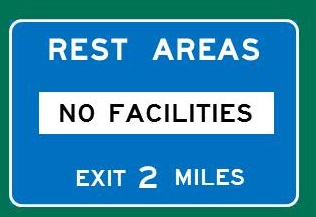
Rest Area - Milepost 20.7
Rest Area - No Facilities/Trucks
|
|
|
|
EXIT 19
Co. Rt. 517 North
Allamuchy Township
Andover
Co. Rt. 517 South
Hackettstown
Centenary College
|

|
EXIT 19
Directions
ALLAMUCHY TOWNSHIP
Rutherfurd Hall, 1/4 mile south
LIBERTY TOWNSHIP
Pequest Trout Hatchery and Nature Education Center,
13 1/2 miles SW
|
|
EXIT 12
Co. Rt. 521 North
Blairstown
Co. Rt. 521 South
Hope
|

|
EXIT 12
Directions
HOPE
Hope Museum, 1 3/4 miles south
Jenny Jump State Forest, 4 3/4 miles east
Land of Make Believe, 2 miles south
United Astronomy Clubs of America Observatory,
5 miles east
STILLWATER TOWNSHIP
Stillwater Historical Museum, 11 miles north
WHITE TOWNSHIP
Four Sisters Winery at Matarazzo Farms,
5 3/4 miles SW
White Township Museum, 7 3/4 miles SW
|
|
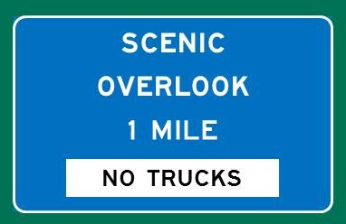
Scenic Overlook -
Milepost 6.5
Scenic Overlook - No Trucks
|
|
|
|
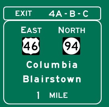
EXIT 4C
NJ 94 North
Blairstown
Knowlton Township
EXIT 4B
US 46 East
Belvidere
Columbia
Easton PA via PA 611
Portland PA via PA 611
Portland-Columbia Bridge
|
Continue east on
Continue north on 
|
EXIT 4C
Directions
KNOWLTON TOWNSHIP
Brook Hollow Winery, 1/2 mile NE
 Lakota Wolf Preserve, 4 miles NE Lakota Wolf Preserve, 4 miles NE
EXIT 4B
Directions
BELVIDERE
Warren County Historical Society Museum, 9 miles south
|
|
Hainesburg Rd Exit -
Milepost 3.4
|

|
|
|
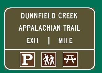
Dunnfield Creek Parking Area -
Milepost 1.0
Appalachian Trail Access
Dunnfield Creek Access
Parking Area
U-Turn
|
|
|
|
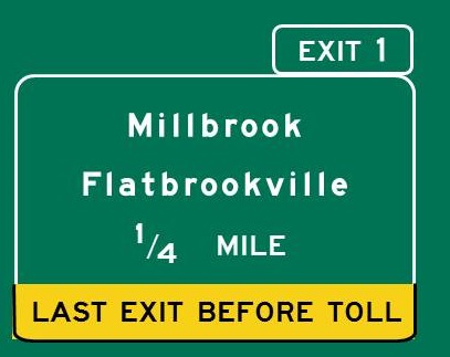
EXIT 1
Hardwick Township
Walpack Township
|
|
EXIT 1
Directions
HARDWICK TOWNSHIP
Delaware Water Gap National Recreation Area,
1/4 mile east
Millbrook Village, 12 miles NE
Worthington State Forest, 3 miles NE
|
|
Delaware River
Bridge
|

Car toll - EZ Pass, $1.25/Cash or toll by mail, $3
|
|
|
|
Home
|
|
