|
Home
|

|
|
School House Rd.
Garden State Parkway Connector
Chestnut Ridge NY
Mahwah
Montvale
Park Ridge
Ramsey
Upper Saddle River
Ramapo College
|

|
School House Rd.
Directions
ALLENDALE
 The Celery Farm, 6 3/4 miles SW The Celery Farm, 6 3/4 miles SW
PARK RIDGE
 Pascack Historical Society Museum, 3 miles south Pascack Historical Society Museum, 3 miles south
 Wortendyke Barn, 2 miles SE Wortendyke Barn, 2 miles SE
UPPER SADDLE RIVER
Hopper-Goetschius House, 3 1/4 miles SW
|
|
|

|
|
|
James Gandolfini
Service Area
Auntie Anne's
Burger King
Dunkin' Donuts
Nathan's
Sunoco
Travel Mart
Vending Machines
|
James Gandolfini Service Area
Milepost 171.0
|
|
|
|
Pascack Valley Toll Plaza
Milepost 166.1
Car Toll $2.10
EZ Pass Express lanes, keep left
Cash and EZ Pass Booth lanes, keep right
|
|
|
Exit 166
Linwood Ave.
Hillsdale
Hohokus
Ridgewood
Washington Twp (Bergen)
Westwood
Valley Hospital
|

|
Exit 166
Directions
CLOSTER
 Belskie Museum of Art & Science, 7 miles east Belskie Museum of Art & Science, 7 miles east
HO-HO-KUS
The Hermitage, 4 miles NW
RIDGEWOOD
Schoolhouse Museum, 2 miles NW
WALDWICK
 Gearblock Brewing Co., 4 3/4 miles NW Gearblock Brewing Co., 4 3/4 miles NW
|
|
Paramus Toll Booth
On-ramp - Cars $.75
EXIT 165B
E. Ridgewood Ave.
Paramus
Ridgewood
Fashion Center Mall
EXIT 165A
Oradell Ave.
Oradell
Bergen Regional Medical Ctr
|

|
Exit 165B
Directions
GLEN ROCK
Thielke Arboretum, 4 3/4 miles west
RIDGEWOOD
James Rose Center, 2 1/2 miles NE
Exit 165A
Directions
ORADELL
Bergen County Players, 2 1/4 miles SE
Hiram Blauvelt Art Museum, 3 3/4 miles east
From Rd.
Directions
PARAMUS
 Bury the Hatchet, 1 mile south Bury the Hatchet, 1 mile south
Humdingers, 1 mile south
Sandbox VR, 1 1/2 miles SW
|
|
Exit 163
Bronx NY
Englewood
Fort Lee
Hackensack
Lodi
Paramus
Teaneck
Bergen Town Center
via NJ 4 East
Fairleigh Dickinson University -
Teaneck Campus via NJ 4 E
Felician College
Garden State Plaza
George Washington Bridge
via NJ 4 East
Meadowlands Sports Complex
Meadowlands Arena
Meadowlands Racetrack
MetLife Stadium
Teterboro Airport
via US 46 East
|

Continue south on 
|
Exit 163
Directions
ENGLEWOOD
Bergen Performing Arts Center, 8 1/2 miles SE
FAIR LAWN
Garretson Forge and Farm, 4 1/2 miles west
HAWTHORNE
Passaic County Arts Center, 7 3/4 miles west
PARAMUS
Arena STEM, 1 3/4 miles south
 Bergen County Zoological Park, 2 1/4 miles east Bergen County Zoological Park, 2 1/4 miles east
Ciccone Theater, 2 1/2 miles NW
Gallery Bergen, 2 1/2 miles NW
Paramus Fritz Behnke Historical Museum,
2 1/4 miles NW
TETERBORO
Aviation Hall of Fame and Museum of New Jersey,
5 1/2 miles south
|
|
Exit 159
Midland Ave.
I-80 West Exits 61-1
Elmwood Park
Morristown
Parsippany-Troy Hills
Paterson
Totowa
Wayne
Woodland Park
Passaic County Comm Coll
St Joseph's Regional
Medical Center
William Paterson University
I-80 East Exits 63-68
Bronx NY
Englewood
Fort Lee
Rochelle Park
Saddle Brook
Teaneck
George Washington Bridge
|

Continue east / west on 
|
Exit 159
Directions
GARFIELD
 Wildlife Conservation and Education Center, Wildlife Conservation and Education Center,
2 1/4 miles south
HALEDON
American Labor Mus/Botto House Natl Landmark,
6 1/2 miles NW
PATERSON
Lambert Castle, 4 1/2 miles west
Paterson Great Falls National Historical Park,
4 1/4 miles west
Paterson Museum, 4 1/4 miles west
PCCC Art Galleries, 4 1/4 miles west
WOODLAND PARK
Garret Mountain Reservation, 5 1/2 miles west
Rifle Camp Park, 5 3/4 miles SW
|
|
Exit 157
Clifton
Elmwood Park
Garfield
Newark via NJ 21
Passaic via NJ 21
Paterson
St Mary's Hospital via NJ 21
|

Continue west on 
|
|
|
Exit 154
Clifton Toll Plaza
Off-ramp - Cars $.75
Clifton
Little Falls
Wayne
Woodland Park
Yogi Berra Stadium
Montclair State University
|

Continue west on
|
Exit 154
Directions
CEDAR GROVE
Mills Reservation, 3 miles SW
CLIFTON
Clifton Arts Center and Sculpture Garden, 1 1/4 miles SE
Hamilton House Museum, 1 1/2 miles SW
LITTLE FALLS
Yogi Berra Museum and Learning Center,
1 3/4 miles SW
MONTCLAIR
Alexander Kasser Theater, 2 1/2 miles SW
George Segal Gallery, 2 1/2 miles west
|
|
Exit 153
Passaic Toll Plaza
Off-ramp - Cars $.75
Lyndhurst
Midtown Manhattan
Nutley
Rutherford
Secaucus
Lincoln Tunnel
Meadowlands Sports Complex
Meadowlands Arena
Meadowlands Racetrack
MetLife Stadium
Styertowne Shopping Center
|

Continue east on 
|
Exit 153
Directions
CLIFTON
Ghost Hawk Brewing Co., 4 1/2 miles SE
EAST RUTHERFORD
American Dream Complex, 6 3/4 miles SE
DreamWorks Water Park
LEGOLAND Discovery Center
Nickelodeon Universe
Sea Life Aquarium
TiLT Museum
LYNDHURST
Meadowlands Environment Center, 7 miles SE
RUTHERFORD
Meadowlands Museum, 5 1/2 miles SE
|
|
Brookdale South
Service Area
|
Brookdale South Service Area
Milepost 153.0
Temporarily closed - no services.
|
|
|
Exit 151
Watchung Ave.
Watchung Toll Plaza
Off-ramp -
Cars $1.05
Bloomfield
Nutley
Montclair - Upper Montclair
|

|
Exit 151
Directions
CALDWELL
Grover Cleveland Birthplace State Historic Site,
6 miles west
MONTCLAIR
Israel Crane House, 3 1/4 miles SW
Essex County Rose Garden, 1 3/4 miles NW
Montclair Art Museum, 3 1/4 miles SW
Van Vleck House and Gardens, 2 3/4 miles west
Wellmont Theater, 3 miles SW
NUTLEY
Jersey Axe House, 2 3/4 miles SE
|
|
|
Essex Toll Plaza
Milepost 150.7
Car toll $2.10
EZ Pass or Cash, use appropriate lane
|
|
|
Exit 149
Belleville Ave.
Belleville
Bloomfield
Glen Ridge
Montclair
Mountainside Hospital
|

|
Exit 149
Directions
MONTCLAIR
Gravity Vault, 1 3/4 miles NW
Montclair Brewery, 2 1/4 miles NW
|
|
Exit 148
Bloomfield Ave.
Franklin St.
Bloomfield Toll Plaza
On-ramp - Cars $.75
Bloomfield
Newark - North Newark
Bloomfield College
Clara Maass Medical Center
|

|
Exit 148
Directions
BLOOMFIELD
Bury the Hatchet, 3/4 mile NW
Museum of the Historical Society of Bloomfield,
1/2 mile NW
Varitage Brew Works, 1/2 mile west
|
|
Exit 147
Springdale Ave.
East Orange
|

|
|
|
Exit 145
Central Ave.
East Orange Toll Plaza
On-ramp - Cars $1.45
East Orange
East Orange General Hospital
I-280 East Exits 13-17
Harrison
Kearny
Newark - Center City/
Ironbound/North Newark/
University Hts
Essex County College
New Jersey Institute
of Technology
Prudential Center
Red Bull Arena
Riverfront Stadium
Rutgers School of
Dental Medicine
Rutgers University -
New Jersey Medical School
Rutgers University -
Newark Campus
St Michael's Medical Center
University Hospital
I-280 West Exits 11B-1
Livingston
Orange
Parsippany-Troy Hills
West Orange
I-80 West Exits 43-1
|

Continue east / west on 
|
Exit 145
Directions
NEWARK
All Points West Distillery, 4 1/4 miles SE
Jewish Museum of New Jersey, 2 1/4 miles east
New Jersey Historical Society, 3 1/4 miles SE
New Jersey Performing Arts Center, 3 1/2 miles SE
Newark Museum of Art, 2 1/4 miles SE
Paul Robeson Galleries, 2 1/2 miles SE
ORANGE
Four City Brewing Co., 1 1/2 miles NW
WEST ORANGE
Eagle Rock Reservation, 4 3/4 miles NW
Thomas Edison National Historical Park, 3 miles NW
South Mountain Recreation Complex, 5 miles NW
South Mountain Reservation, 5 miles NW
Turtle Back Zoo, 4 1/2 miles NW
|
|
Exit 144
Irvington Toll Plaza
On-ramp - Cars $.75
Co. 510 East
Newark - Vailsburg
Co. 510 West
South Orange
East Orange VA Med Ctr
Seton Hall University
|

|
Exit 144
Directions
SOUTH ORANGE
South Orange Performing Arts Center, 3 1/4 miles west
Walsh Gallery, 2 miles west
|
|
Exit 143C
Springfield Ave.
Irvington
|

Continue west on 
|
|
|
Lyons Ave.
Union Ave.
Exit 143B
Irvington
Maplewood
Exit 143A
Hillside
|

|
|
|
Exit 142B
Berkeley Heights
Bridgewater Township
Clinton
Millburn
Morristown
New Providence
Phillipsburg
Springfield
Summit
Exit 142A
Hillside
Jersey City
Lower Manhattan -
Financial District
Newark - Weequahic
Holland Tunnel
New Jersey Turnpike
Newark Beth Israel Med Ctr
Newark Liberty Int'l Airport
|

Continue east / west on 
|
Exit 142B
Directions
MILLBURN
Paper Mill Playhouse, 3 1/2 miles NW
MORRISTOWN
Morristown National Historical Park, 16 miles west
SHORT HILLS
Greenwood Gardens, 4 1/2 miles NW
Cora Hartshorn Arboretum and Bird Sanctuary,
6 1/2 miles west
|
|
Exit 141
Elizabeth
Maplewood
Union
Kean University
|

|
Exit 141
Directions
UNION
Galleries at Kean University, 2 1/4 miles SE
Kean Stage, 2 miles SE
Liberty Hall, 2 miles SE
|
|
Exit 140B
US 22 West
Plainfield
Scotch Plains
Somerville
NJ 82 East
Elizabeth
Staten Island NY
Goethals Bridge via NJ 439
Trinitas Reg Medical Ctr
|

Continue east / west on 
|
EXIT 140B
Directions
SPRINGFIELD
Lively Laser Tag, 5 1/4 miles west
Sky Zone Trampoline Park, 5 miles west
|
|
Exit 140A
Springfield
Union
|

|
|
|
Exit 138
Kenilworth Blvd./
Galloping Hill Rd.
Co. Rt. 509 North
Elizabeth
Roselle Park
Co. Rt. 509 South
Kenilworth
Union County College
|

|
Exit 138
Directions
CRANFORD
William Miller Sperry Observatory, 2 1/2 miles west
KENILWORTH
Tree City Spirits, 1 1/2 miles NE
|
|
Exit 137
NJ 28 East
Roselle
Roselle Park
NJ 28 West
Cranford
Westfield
|

Continue east / west on 
|
Exit 137
Directions
CRANFORD
Crane-Phillips House Living Museum, 3/4 mile west
Cranford Dramatic Club Theatre, 1 1/4 miles south
Yale Terrace Brewery, 1 mile west
ROSELLE PARK
Climax Brewing Co., 1/2 mile east
Pump It Up, 1 1/2 miles east
WESTFIELD
YESTERcades, 3 1/2 miles west
|
|
Exit 136
Centennial Ave.
Cranford
Linden
Roselle
Winfield Park
|

|
|
|
Exit 135
Central Ave./
Valley Rd.
Clark
Rahway
Westfield
RWJ University Hospital Rahway
|

|
Exit 135
Directions
RAHWAY
Merchants and Drovers Tavern, 1 3/4 miles SE
River City Gaming, 2 1/2 miles SE
Union County Performing Arts Center, 2 1/4 miles SE
Wet Ticket Brewing Co., 3 miles SE
WOODBRIDGE
Bury the Hatchet, 3 1/2 miles SE
|
|
Colonia South
Service Area
Circle K
Dunkin' Donuts
Exxon
Subway
|
Colonia South Service Area
Milepost 133.0
|
|
|
Exit 132
NJ 27 North
Colonia
Iselin
Rahway
Woodbridge Township
NJ 27 South
Edison Township
Menlo Park
Metuchen
John F. Kennedy Med Ctr
|

Continue north / south on 
|
Exit 132
Directions
EDISON
Thomas Edison Center at Menlo Park, 3/4 miles west
|
|
Exit 131
Metropark Station
Amtrak
NJ Transit
|

|
|
|
Exit 130B
US 1 South
Edison Township
Highland Park
New Brunswick
Trenton
Menlo Park Mall
Exit 130A
US 1 North
Newark
Woodbridge Township
Woodbridge Center Mall
|

Continue north / south on 
|
Exit 130B
Directions
EDISON
Supercharged Entertainment, 3 3/4 miles SW
Exit 130A
Directions
WOODBRIDGE
Altitude Trampoline Park, 1 1/2 miles NE
Avenel Performing Arts Center, 2 3/4 miles NE
Barron Arts Center, 3 miles east
SeaQuest Woodbridge, 1 mile east
|
|
Exit 129
New Jersey Turnpike North Exits 12-18
Carteret
New Jersey Turnpike South Exits 10-1
Camden
Hightstown
Mount Holly
Philadelphia PA
Trenton
Delaware Memorial Bridge
Princeton University
Rutgers University
I-287 North
Edison Township
Piscataway Township
Somerville
Raritan Center
NJ 440 North
Perth Amboy
Staten Island NY
Outerbridge Crossing
US 9 South
South Amboy
Edison Bridge
Raritan Bay Medical Center
via New Brunswick Ave.
|

Continue north on 
Continue north / south on  
Continue north / south on 
Continue north / south on 
|
Exit 129
Directions
EDISON
Cypress Brewing Co., 4 1/2 miles SW
PERTH AMBOY
Kearny Cottage, 3 1/2 miles east
Proprietary House, 4 miles east
|
|
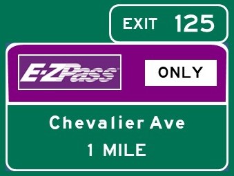
Exit 125
Car toll $2.10
EZ Pass payment only
Sayreville
South Amboy
|
|
Exit 125
Directions
SAYREVILLE
Cars with EZ Pass only
Sayreville Historical Society Museum, 3 1/2 miles SW
|
|
|
Raritan Toll Plaza
Milepost 125.4
Car toll $2.10
EZ Pass Express lanes, keep left
Cash and EZ Pass Booth lanes, Exit 124 traffic, keep right
|
|
|
Parkway Divides - Milepost 125.3
Lanes divide from Exit 124 to Exit 105; express lanes access only Exits 117 and 105
|
|
|
|
Exit 124
Sayreville
South Amboy
South River
|

|
Exit 124
Directions
SAYREVILLE
Cars without EZ Pass
Sayreville Historical Society Museum, 2 3/4 miles west
|
|
Exit 123
Freehold
Marlboro Township
Old Bridge Township
Sayreville
Freehold Raceway
|

Continue south on
|
Exit 123
Directions
OLD BRIDGE
Thomas Warne Historical Museum, 7 miles SE
SAYREVILLE
Starland Ballroom, 4 3/4 miles SW
|
|
Bon Jovi
Service Area
Auntie Anne's
Burger King
Nathan's
Sbarro
Starbucks
Sunoco
Travel Mart
Vending Machines
|
Bon Jovi Service Area
Milepost 124.0
|
|
|
Exit 120
Matawan Rd.
Laurence Harbor
Matawan
Old Bridge Township
|

|
Exit 120
Directions
CLIFFWOOD
Airplay, 2 3/4 miles east
OLD BRIDGE
Bury the Hatchet, 1 1/2 miles SW
Cheesequake State Park, 1 1/4 miles west
|
|
Exit 118
Lloyd Rd.
Matawan Toll Plaza
Off Ramp - Car toll $.75
Aberdeen Township
Matawan
|

|
Exit 118
Directions
ABERDEEN
Alternate Ending Beer Co., 2 miles SW
MATAWAN
Burrowes Mansion Museum, 1 1/2 miles west
|
|
Exit 117
Keyport-Hazlet Toll Plaza
Off Ramp - Car toll $.75
NJ 35 South
Hazlet Township
Middletown Township
Bayshore Comm Hospital
NJ 36 South
Atlantic Highlands
Highlands
Keansburg
Keyport
|

Continue north / south on 
Continue south on 
|
Exit 117
Directions
ATLANTIC HIGHLANDS
Carton Brewing Co., 10 miles east
First Avenue Playhouse, 10 miles east
Strauss Mansion, 10 1/4 miles east
HAZLET
Urban Air Adventure Park, 1 1/2 miles east
HIGHLANDS
Twin Lights State Historic Site, 13 1/4 miles east
KEANSBURG
Grin Brewing, 4 1/2 miles east
Keansburg Amusement Park/Runaway Rapids,
5 1/4 miles NE
KEYPORT
3BR Distillery, 1 1/2 miles north
Keyport Fire Museum and Education Center,
1 mile north
Keyport Historical Society Museum, 1 1/2 miles north
MIDDLETOWN
Belford Brewing Co., 7 miles east
Hartshorne Woods Park
Buttermilk Valley, 11 1/2 miles east
Claypit Creek, 11 miles east
Rocky Point, 14 miles east
Ross Brewing Co., 7 3/4 miles east
SANDY HOOK
Gateway National Recreation Area (Sandy Hook Unit),
13 1/4 miles east
|
|
|

|
HOLMDEL
New Jersey Vietnam Veterans' Memorial/
Vietnam Era Museum and Educational Center
PNC Bank Arts Center
|
|
Exit 114
Red Hill Rd.
Holmdel Toll Plaza
Off ramp - Cars $.75
Holmdel Township
Middletown Township
|

|
Exit 114
Directions
COLTS NECK
Four JG's Orchards and Vineyards, 8 1/4 miles SW
HOLMDEL
Fox Hollow Vineyards, 3 1/2 miles SW
Holmdel Theatre Co., 2 1/2 miles west
Holmes-Hendrickson House, 3 miles west
Longstreet Farm, 2 3/4 miles west
David C. Shaw Arboretum, 2 3/4 miles west
MIDDLETOWN
Deep Cut Gardens, 1 3/4 miles NE
Gravity Vault (Middletown), 5 miles east
Marlpit Hall/Taylor-Butler House, 2 1/2 miles NE
Middletown Arts Center, 2 3/4 miles NE
Poricy Park Conservancy, 3 miles east
|
|
Exit 109
Newman Springs Rd.
Red Bank Toll Plaza
Off ramp - Cars $.75
Colts Neck Township
Lincroft
Little Silver
Middletown Township
Red Bank
Rumson
Shrewsbury
Tinton Falls
Brookdale Community College
Riverview Medical Center
|

|
Exit 109
Directions
LINCROFT
Brookdale Performing Arts Center, 1 1/2 miles west
Center for the Visual Arts Gallery, 1 1/2 miles west
Monmouth Museum, 1 1/2 miles west
MIDDLETOWN
Huber Woods Environmental Center, 6 miles NE
RED BANK
Count Basie Center for the Arts, 2 miles NE
Red Tank Brewing Co., 3 miles NE
Two River Theater, 2 1/2 miles NE
YESTERcades, 2 3/4 miles NE
SHREWSBURY
Allen House, 3 miles SE
|
|
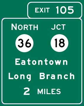
Exit 105
NJ 18 North
Colts Neck
NJ 18 South
Asbury Park
Oakhurst
Ocean Township
NJ 36 North
Eatontown
Long Branch
Oceanport
West Long Branch
Monmouth Mall
Monmouth Medical Center
Monmouth Park Race Track
Monmouth University
|
Continue north / south on 
Continue north on
Express and local lanes merge - Milepost 104
|
Exit 105
Directions
COLTS NECK
Colts Neck Stillhouse, 4 1/2 miles west
Source Farmhouse Brewery, 4 1/2 miles west
EATONTOWN
F. Bliss Price Arboretum and Wildlife Sanctuary,
2 1/4 miles NE
Stumpy's Hatchet House, 2 1/2 miles SE
FREEHOLD
Monmouth County Historical Association Museum,
11 1/2 miles west
LONG BRANCH
Beach Bee Meadery, 5 3/4 miles east
Boardwalk Fun and Games, 6 miles east
Long Branch Distillery, 5 miles east
New Jersey Repertory Company, 4 3/4 miles east
OCEAN TOWNSHIP
Axelrod Performing Arts Center, 6 miles SE
Kane Brewing Co., 6 1/2 miles SE
Township of Ocean Historical Museum, 5 1/2 miles SE
OCEANPORT
Birdsmouth Beer, 3 1/4 miles NE
WEST LONG BRANCH
Monmouth University Center for the Arts,
4 1/2 miles east
|
|
Exit 102
Asbury Ave.
Asbury Park
Neptune
Asbury Park Convention Center
|

|
Exit 102
Directions
ASBURY PARK
Asbury Park Brewery, 4 1/2 miles east
Asbury Park Distilling, 4 3/4 miles SE
Asbury Splash Park/Asbury Eighteen, 5 miles east
Stephen Crane House, 5 miles east
Silverball Museum Arcade, 5 1/4 miles east
OCEAN TOWNSHIP
Sky Zone Trampoline Park (Ocean Township),
3 1/4 miles east
TINTON FALLS
Twin Lights Brewing Co., 1/2 mile SE
|
|
Exit 100B
NJ 33 West
Freehold
Hightstown
Howell Township
Jersey Shore
Premium Outlets
via NJ 66 East
U.S. Naval Weapons Station
Earle
Exit 100A
NJ 33 East
Avon-by-the-Sea
Bradley Beach
Neptune
Ocean Grove
Jersey Shore Medical Center
K. Hovnanian
Children's Hospital
|

Continue east / west on 
|
Exit 100B
Directions
FREEHOLD
Covenhoven House, 11 miles west
Jewish Heritage Museum of Monmouth County,
12 miles west
MANALAPAN
Monmouth Battlefield State Park, 12 1/4 miles west
TINTON FALLS
Jughandle Brewing Co., 1/4 mile west
Exit 100A
Directions
OCEAN GROVE
Historical Society of Ocean Grove Museum,
5 1/4 miles east
WALL TOWNSHIP
InfoAge Science/History Learning Center, 5 miles SE
|
|
Judy Blume
Service Area
Auntie Anne's
Shake Shack
Starbucks
Sunoco
Vending Machines
Z Market
|
Judy Blume Service Area
Milepost 100.0
|
|
|
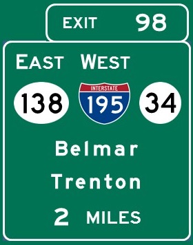
Exit 98
Belmar-Wall Toll Plaza
Off ramp - Cars $.75
I-195 West
Howell Township
Jackson Township
Trenton
NJ 34 North
Monmouth Executive Airport
Wall Stadium Speedway
NJ 34 South
Brielle
Manasquan
Point Pleasant
Sea Girt
Wall Township
National Guard Training Ctr
NJ 138 East
Belmar
Lake Como
Spring Lake
Wall Township
|
Continue west on 
Continue north / south on 
|
Exit 98
Directions
BELMAR
Beach Haus Brewery, 5 miles east
Belmar Historical Society Museum, 4 miles east
Go Play Arcade, 4 1/4 miles east
JACKSON
Six Flags Great Adventure, 20 miles west
MANASQUAN
Algonquin Arts Theatre, 5 3/4 miles SE
Squan Village Historical Society Museum, 6 miles NE
POINT PLEASANT BEACH
Jenkinson's Aquarium, 7 1/2 miles SE
Point Pleasant Historical Society Museum, 6 miles SE
SEA GIRT
National Guard Militia Museum of New Jersey,
5 3/4 miles SE
Sea Girt Lighthouse, 6 1/4 miles SE
SPRING LAKE
Spring Lake Historical Society Museum, 5 1/4 miles SE
Spring Lake Theatre Company, 5 3/4 miles SE
WALL TOWNSHIP
Allaire State Park, 3 3/4 miles SW
New Jersey Museum of Transportation, 3 3/4 miles SW
Old Wall Historical Society, 2 1/2 miles east
|
|
Brick Toll Plaza
Off ramp - Cars $.75
Exit 91B
Burnt Tavern Rd.
Co. 549 South
Brick Township
Lakewood
Georgian Court University
Ocean Medical Center
Exit 91A
Lanes Mills Rd.
Co. 549 North
Point Pleasant
|

|
Exit 91B
Directions
LAKEWOOD
Sister Mary Grace Burns Arboretum, 4 3/4 miles west
Lakewood Historical Museum, 6 1/2 miles west
Strand Center for the Arts, 4 1/2 miles west
Exit 91A
Directions
BRICK TOWNSHIP
Havens Homestead Museum, 2 3/4 miles NE
Pirate Adventures Jersey Shore, 4 miles SE
POINT PLEASANT
Bay Head Historical Society Museum, 5 1/2 miles east
New Jersey Museum of Boating, 5 1/2 miles east
Vintage Automobile Museum of New Jersey,
5 1/2 miles east
|
|
Lakewood Toll Plaza
Off ramp - Cars $.75
Exit 89C
Cedar Bridge Ave.
Co. 528 East
Brick Township
Mantoloking
Brick Plaza
Co. 528 West
Lakewood
First Energy Park
Lakewood Airport
Monmouth Medical Center
(Southern Campus)
Exit 89B
NJ 70 West
Camden
Lakehurst
Lakewood
Manchester Township
Medford
Joint Base MDL
Fort Dix
Lakehurst Naval Air Station
McGuire AFB
Ocean County College
Exit 89A
NJ 70 East
Brick Township
|

Continue east / west on 
|
Exit 89C
Directions
LAKEWOOD
Icarus Brewing, 1 1/2 miles NW
Exit 89B
Directions
LAKEHURST
Lakehurst Historical Society Museum, 8 1/4 miles SW
LAKEWOOD
Sky Zone Trampoline Park, 2 miles west
TOMS RIVER
Insectropolis, 5 1/4 miles SW
Exit 89A
Directions
TOMS RIVER
Jay and Linda Grunin Center for the Arts,
4 3/4 miles south
Robert J. Novins Planetarium, 4 3/4 miles south
|
|
|
Toms River Toll Plaza
Milepost 84.7
Car toll $1.05
EZ Pass Express lanes, keep left
Cash or EZ Pass Booth lanes, keep right
|
|
|
Exit 82A
Lakehurst
Manchester Township
Community Medical Center
HealthSouth Rehabilitation Ctr
Exit 82
Island Heights
Lavallette
Seaside Heights
Seaside Park
Toms River
Ocean County Mall
|

Continue east / west on 
|
Exit 82A
Directions
TOMS RIVER
Bury the Hatchet, 3 1/4 miles north
GamerNook eSports Center, 3 1/4 miles north
Toms River Brewing, 3 1/2 miles NW
Urban Air Adventure Park, 3 1/4 miles north
Exit 82
Directions
ISLAND HEIGHTS
Cottage Museum, 4 miles SE
Ocean County Artists Guild, 3 3/4 miles east
John F. Peto Studio Museum, 4 1/2 miles SE
ORTLEY BEACH
Barnacle Bill's Amusements, 8 1/2 miles east
SEASIDE HEIGHTS
Casino Pier and Breakwater Beach, 8 miles east
Coin Castle, 8 miles east
SEASIDE PARK
Island Beach State Park, 10 miles SE
TOMS RIVER
Action Time VR, 2 3/4 miles NE
Cattus Island County Park/Cooper Environmental Ctr,
7 miles NE
Ocean County Historical Museum, 1 3/4 miles SE
VRtual Nexgen Gaming Arcade, 2 miles east
|
|
Exit 81
Toms River
|

|
Exit 81
Directions
TOMS RIVER
Battle River Brewing, 3/4 mile east
Bounce About Laser Tag, 1 mile SE
Garden State Distillery, 1 mile east
Toms River Maritime Museum, 1 mile east
|
|
Exit 80
Co. 530 West
South Toms River
Whiting
US 9 South
Bayville
Beachwood
Berkeley Township
Ocean Gate
Pine Beach
|

Continue south on
|
Exit 80
Directions
BEACHWOOD
Jakes Branch County Park, 3/4 mile south
BERKELEY TOWNSHIP
Hovnanian Sanctuary, 1 3/4 miles SW
LACEY TOWNSHIP
Popcorn Park Animal Refuge, 7 1/2 miles SW
|
|
Exit 77
Double Trouble Rd./
Pinewald-Keswick Rd.
Berkeley Toll Plaza
Off ramp - Cars $.75
Bayville
Berkeley Township
Whiting
|

|
Exit 77
Directions
BERKELEY TOWNSHIP
Double Trouble State Park, 1/2 mile SW
|
|
Celia Cruz
Service Area
Burger King
Dunkin'
EVGo Charging Station
Nathan's
Sunoco
Vending Machines
Z Market
|
Celia Cruz Service Area
Milepost 76.0
|
|
|
Exit 74
Lacey Rd.
Lacey Toll Plaza
Off ramp - Cars $.75
Forked River
Lacey Township
Forked River State Marina
|

|
Exit 74
Directions
FORKED RIVER
Old Schoolhouse Museum, 2 1/2 miles SE
LACEY TOWNSHIP
Backward Flag Brewing Co., 4 miles south
|
|
Exit 69
Wells Mills Rd.
Waretown Toll Plaza
Off ramp -
Cars $1.05
Ocean Township (Ocean County)
Waretown
|

|
Exit 69
Directions
OCEAN TOWNSHIP
Wells Mills County Park, 2 1/4 miles west
WARETOWN
Albert Music Hall, 2 miles east
Little Red Schoolhouse Museum, 1 1/2 miles east
WOODLAND TOWNSHIP
Franklin Parker Preserve, 18 1/4 miles west
|
|
|
Barnegat Toll Plaza
Milepost 68.9
Car toll $2.10
EZ Pass Express lanes, keep left
Cash and EZ Pass Booth lanes, keep right
|
|
|
W.Bay Ave.
Exit 67B
Chatsworth
Pemberton
Exit 67A
Barnegat
|

|
EXIT 67B
Directions
BARNEGAT TOWNSHIP
Cedar Bridge Tavern Historic Site, 6 miles west
|
|
Exit 63
NJ 72 West
Camden
Chatsworth
Pemberton
Southern Ocean Medical Ctr
Stafford Park Mall
NJ 72 East
Barnegat Light
Beach Haven
Eagleswood Township
Harvey Cedars
Long Beach Island
Manahawkin
Ship Bottom
Stafford Township
Surf City
Ocean County College -
Southern Education Ctr
|

Continue east / west on 
|
Exit 63
Directions
BARNEGAT LIGHT
Barnegat Light Museum, 15 3/4 miles NE
Barnegat Lighthouse State Park, 16 miles NE
BEACH HAVEN
Fantasy Island, 13 3/4 miles south
Long Beach Island Museum, 14 1/4 miles south
New Jersey Maritime Museum, 14 1/4 miles south
Surflight Theatre, 14 1/4 miles south
Thundering Surf Water Park, 13 3/4 miles south
MANAHAWKIN
Mainland Adventure Park, 1 1/2 miles SE
ManaFirkin Brewing Co., 3 miles SE
Stafford Township Arts Center, 1 1/2 miles SW
Stafford Township Heritage Center, 2 miles SE
|
|
Exit 58
Co. Rt. 539 North
Warren Grove
Co. Rt. 539 South
Little Egg Harbor Township
Tuckerton
|

|
Exit 58
Directions
TUCKERTON
Jacques Cousteau Natl Estuarine Research Reserve,
4 1/4 miles south
Pinelands Brewing Co., 2 3/4 miles south
Tuckerton Historical Society Museum, 4 3/4 miles south
Tuckerton Seaport and Baymen's Museum,
3 3/4 miles south
|
|
Exit 52
E. Greenbush Rd.
Bass River Township
New Gretna
|

|
Exit 52
Directions
BASS RIVER TOWNSHIP
Bass River State Forest, 1 1/4 miles north
Jersey Shore Live Steam Co., 2 1/4 miles SW
WASHINGTON TOWNSHIP
Batsto Village, 13 1/4 miles west
Wharton State Forest
Batsto area, 13 1/4 miles west
|
|
Exit 48
Galloway Township
Oceanville
Port Republic
Smithville
|

Continue south on
|
Exit 48
Directions
OCEANVILLE
Edwin B. Forsythe National Wildlife Refuge,
6 miles south
SMITHVILLE
Historic Town of Smithville, 4 miles south
|
|
Exit 44
Pomona Rd.
Moss Mill Rd.
Egg Harbor City
Galloway Township
Hammonton
Pomona
Smithville
Atlantic City Race Track
Stockton University
|

|
Exit 44
Directions
EGG HARBOR CITY
Renault Winery, 6 1/2 miles NW
GALLOWAY TOWNSHIP
Stockton Performing Arts Center, 1 1/4 miles SW
Stockton University Art Gallery, 1 1/4 miles SW
|
|
Exit 41
Jimmie Leeds Rd.
Egg Harbor City
Galloway Township
AtlantiCare Regional Medical
Center (Mainland Campus)
Bacharach Institute for
Rehabilitation
|

|
|
|
Frank Sinatra Service Area
Auntie Anne's
Burger King
Starbucks
Sunoco
Vending Machines
Z Market
|
Frank Sinatra Service Area
Milepost 41.4
|
|
|
Exit 40
Absecon
Atlantic City - Marina/Uptown
Brigantine
Farley State Marina
|

Continue east on 
|
Exit 40
Directions
ATLANTIC CITY
Absecon Lighthouse, 10 miles SE
Atlantic City Cruises, 10 miles SE
Historic Gardner's Basin/Atlantic City Aquarium,
10 miles SE
BRIGANTINE
Brigantine Historical Museum, 11 1/2 miles SE
Marine Mammal Stranding Center and Museum,
11 1/2 miles SE
GALLOWAY TOWNSHIP
Garden State Beer Co., 1 mile SE
|
|
Exit 38B
Atlantic City Expressway West
Exits 9-44
Camden
Egg Harbor Township
Hamilton Township
(Atlantic County)
Hammonton
Mays Landing
Philadelphia PA
Woodbury
Atlantic Cape Comm Coll -
Mays Landing Campus
Atlantic City Int'l Airport
Ben Franklin Bridge
Walt Whitman Bridge
Exit 38A
Atlantic City Expressway East
Exits 5-1
Atlantic City - Casinos/
Downbeach/Midtown
Pleasantville
Ventnor
Atlantic Cape Comm Coll -
Atlantic City Campus
Atlantic City Convention Ctr
AtlantiCare Reg Medical Ctr
(City Campus)
Boardwalk Hall
|

Continue east / west on 
|
Exit 38B
Directions
EGG HARBOR TOWNSHIP
LWG Lasertag, 2 3/4 miles NW
ESTELL MANOR
Warren E. Fox Nature Center, 14 1/2 miles SW
HAMILTON TOWNSHIP
Balic Winery, 14 miles west
Get Air Trampoline Park, 5 3/4 miles west
Starcade, 5 1/2 miles west
MAYS LANDING
Township of Hamilton Historical Society Museum,
10 3/4 miles west
Exit 38A
Directions
ATLANTIC CITY
African-American Heritage Museum of South Jersey
Atlantic City site, 7 1/2 miles SE
Central Pier Arcade and Speedway, 8 1/2 miles SE
Noyes Art Garage of Stockton University, 7 1/2 miles SE
Steel Pier, 8 3/4 miles SE
|
|
Exit 37
Cardiff Circle Shopping Center
US 40/322 East
Atlantic City - Downbeach
Pleasantville
Ventnor
Cardiff Plaza
Shore Mall
US 40/322 West
Egg Harbor Township
Hamilton Township
US 40 West
Mays Landing
Pennsville
Vineland
Woodstown
Delaware Memorial Bridge
US 322 West
Chester PA
Glassboro
Pitman
Swedesboro
Commodore Barry Bridge
|

Continue east / west on 
Continue east / west on 
|
Exit 37
Directions
EGG HARBOR TOWNSHIP
Greate Egg Harbour Township Historical Society Mus,
1 3/4 miles west
Hidden Sands Brewing Co., 1/4 mile east
Storybook Land, 2 1/2 miles NW
|
|
Exit 36
Linwood
Longport
Margate City
Northfield
|

|
Exit 36
Directions
EGG HARBOR TOWNSHIP
Egg Harbor Township Nature Reserve, 6 1/4 miles SW
LINWOOD
Linwood Historical Society, 4 miles south
LONGPORT
Longport Museum, 8 miles south
MARGATE CITY
Island Aqua Park, 6 1/2 miles south
Lucy, the Margate Elephant, 7 miles south
Margate Historical Society and Museum,
6 3/4 miles south
NORTHFIELD
Casto House/Northfield Museum, 2 1/4 miles south
|
|
Exit 30
Somers Point Toll Plaza
Off ramp -
Cars $2.10
Ocean City
Somers Point
Shore Medical Center
|

|
Exit 30
Directions
OCEAN CITY
Gillian's Wonderland Pier, 4 1/2 miles SE
Greater Ocean City Theatre Company, 4 1/4 miles south
Jilly's Arcade, 4 1/4 miles SE
OC Waterpark, 4 miles SE
Ocean City Arts Center, 4 1/2 miles south
Ocean City Historical Museum, 4 1/2 miles south
Pirate Voyages, 4 1/4 miles SE
Playland's Castaway Cove, 4 1/4 miles SE
Totally Tubular Aqua Park, 4 1/4 miles SE
U.S. Life Saving Station 30, 4 1/2 miles SE
SOMERS POINT
Atlantic County Historical Society, 2 miles east
Gateway Playhouse, 1 3/4 miles east
Somers Mansion State Historic Site, 1 mile south
Somers Point Brewing Co., 1 mile east
Somers Point Historical Museum, 1 3/4 miles SE
|
|
|
Great Egg Toll Plaza
Milepost 28.8
Car toll $2.10
EZ Pass or Cash, use appropriate lane
|
|
|
Exit 25
Roosevelt Blvd.
Marmora
Ocean City
Palermo
Seaville
Upper Township
|

Continue south on
|
Exit 25
Directions
OCEAN CITY
Corson's Inlet State Park, 5 1/4 miles SE
Discovery Seashell Museum, 2 3/4 miles NE
OCEAN VIEW
Endicott Reardon Family Museum, 5 3/4 miles SW
|
|
Ocean View
Service Area
A-Plus Convenience Store
New Jersey Tourism
Information Center
Sunoco
|
Ocean View Service Area
Milepost 18.3
Open 24 hours, Memorial Day-Labor Day
Open 6AM-8PM, rest of year
|
|
|
Exit 17
Sea Isle Blvd.

Clermont
Dennis Township
Dennisville
Sea Isle City
Woodbine
Woodbine Airport
|

|
Exit 17
Directions
DENNIS TOWNSHIP
Slack Tide Brewing Co., 3 miles SW
DENNISVILLE
Dennis Township Museum and History Center,
7 1/2 miles west
MIDDLE TOWNSHIP
Cape May Bird Observatory
Center for Research and Education, 8 1/4 miles west
Sperlak Gallery and Sculpture Gardens,
8 3/4 miles west
SEA ISLE CITY
Island Breeze Casino, 2 3/4 miles east
Sea Isle City Historical Museum, 2 3/4 miles SE
WOODBINE
Sam Azeez Museum of Woodbine Heritage,
7 1/2 miles NW
Belleplain State Forest, 9 miles NW
Ludlam Island Brewery, 5 1/2 miles NW
|
|
Exit 13
Avalon Blvd.

Avalon
Middle Township
Swainton
|

Continue north / south on
|
Exit 13
Directions
AVALON
Avalon History Center, 4 miles SE
MIDDLE TOWNSHIP
Lizard Tail Swamp Preserve, 3 1/2 miles west
Natali Vineyards, 6 miles west
|
|
Exit 11

Cape May Court House
Middle Township
Cape May County Correctional
Center
Cape May County Offices
Crest Haven Nursing and
Rehabilitation Center
|

Continue north / south on
|
Exit 11
Directions
CAPE MAY COURT HOUSE
Cape May County Zoo, 1/4 mile west
Museum of Cape May County, 1/2 mile SW
|
|
Exit 10
Stone Harbor Blvd.

Cape May Court House
Middle Township
Stone Harbor
Atlantic Cape Comm Coll -
Cape May County Campus
Cape Regional Medical Center
|

|
Exit 10
Directions
MIDDLE TOWNSHIP
Cape May National Wildlife Refuge, 4 miles west
Jessie Creek Winery, 3 3/4 miles west
Wetlands Institute, 3 miles SE
STONE HARBOR
RiGi's Amusement Center, 3 3/4 miles SE
Stone Harbor Museum, 4 miles SE
Tatham Life Saving Station and Museum, 5 miles SE
|
|
Exit 9
Mayville
Middle Township
|

Continue north / south on
|
|
|
Exit 6
Burleigh
Middle Township
North Wildwood
Whitesboro
|

|
Exit 6
Directions
MIDDLE TOWNSHIP
Coho Brewing Co., 1/2 mile NW
Shore Craft Distillery, 4 1/4 miles NW
NORTH WILDWOOD
Ed's Funcade, 5 1/2 miles SE
Gateway 26 Casino Arcade, 5 3/4 miles SE
Hereford Inlet Lighthouse, 4 miles SE
|
|
Exit 4B
Wildwood Toll Plaza
On ramp - Car toll $.75
Erma
Lower Township
Rio Grande
Cape May Airport
Exit 4A
Wildwood
Wildwood Crest
Wildwoods Convention Center
|

Continue north / south on 
|
Exit 4B
Directions
LOWER TOWNSHIP
Cape May Brewing Co., 3 1/2 miles west
Forgotten Warriors Vietnam Museum, 3 1/2 miles west
Hawk Haven Vineyard and Winery, 1 1/2 miles west
NAS Wildwood Aviation Museum, 3 1/2 miles west
Exit 4A
Directions
WILDWOOD
George F. Boyer Historical Museum, 3 1/2 miles SE
Doo Wop Experiece Museum, 3 1/2 miles SE
Ed's Funcade, 4 miles SE
Morey's Piers, 3 3/4 miles SE
Silver Bullet Speedboat and Dolphin Watch,
2 1/2 miles SE
Splash Zone Interactive Water Park, 4 miles SE
WILDWOOD CREST
Dark Star Pirate Cruises, 3 1/2 miles SE
|
|
Exit 0
Cold Spring
Lower Township
North Cape May
Cape May-Lewes Ferry
NJ 109 South -
Milepost 0.0
Cape May
Cape May Point
West Cape May
U.S. Coast Guard Training Ctr
|
 
|
Exit 0
Directions
CAPE MAY POINT
Cape May Bird Observatory
Northwood Center, 5 1/2 miles SW
Cape May Point State Park, 6 miles SW
LOWER TOWNSHIP
Cape May Winery, 1 1/2 miles west
Cold Spring Brewery, 2 miles NW
Historic Cold Spring Village, 1 mile NW
Garrett Family Preserve, 2 1/2 miles SW
Nauti Spirits Distillery, 1 3/4 miles west
South Cape May Meadows, 4 1/2 miles SW
WEST CAPE MAY
Willow Creek Winery and Farm, 4 1/4 miles SW
NJ 109 South
Directions
CAPE MAY
Birding By Boat, 1 mile south
Cape May Stage, 2 1/4 miles south
Cape May Whale Watch and Research Center,
1 1/4 miles south
Cape May Whale Watcher, 1 mile south
Colonial House, 2 1/4 miles south
Museum of Fine Arts and Popular Culture,
2 1/4 miles south
Nature Center of Cape May, 2 miles south
Emlen Physick Estate, 1 3/4 miles south
Harriet Tubman Museum of New Jersey, 2 miles south
LOWER TOWNSHIP
Salt Marsh Safari, 2 1/4 miles east
Thunder Cat Dolphin Watch, 2 1/4 miles east
|
|
|
Home
|
|
