|
Home
All exits Lower Level of George Washington Bridge/Local I-95 unless otherwise noted
|

|
|
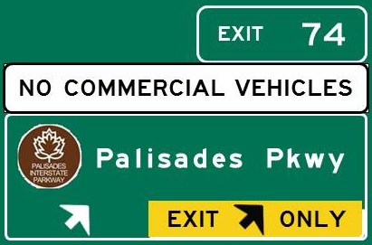
Exit 74
Alpine
Englewood Cliffs
Nyack NY
New York Thruway
|
Upper Level
|
EXIT 74
Directions
 Palisades Interstate Park Palisades Interstate Park
Alpine Area, 8 3/4 miles north
Englewood Picnic Area, 3 miles north
Park Headquarters, 7 3/4 miles north
State Line Overlook, 9 1/2 miles north
|
|
Exit 73
Cliffside Park
Englewood Cliffs
Fort Lee
|
Upper Level/Express Lower Level/Local
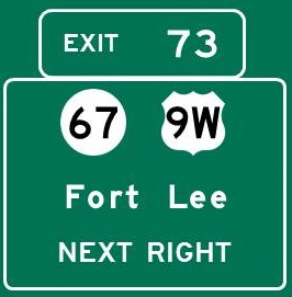 
Continue north on 
|
EXIT 73 (Upper Level)
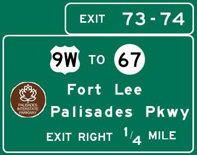
EXIT 73-74 (Lower Level)
Directions
ALPINE/ENGLEWOOD CLIFFS (Lower Level only)
Palisades Interstate Park
Alpine Area, 9 miles north
Englewood Picnic Area, 2 3/4 miles north
Park Headquarters, 7 3/4 miles north
State Line Overlook, 10 1/4 miles north
FORT LEE
 Fort Lee Historic Park, 1/4 mile east Fort Lee Historic Park, 1/4 mile east
 Fort Lee Museum, 3/4 mile south Fort Lee Museum, 3/4 mile south
Palisades Interstate Park
Ross Dock, 1 1/2 miles NE
|
|
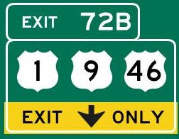
Exit 72B
US 1/9 South
Hoboken
Jersey City
Leonia
North Bergen
Palisades Park
Ridgefield
|
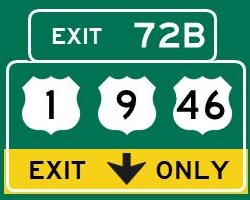 
Continue south on 
Continue south on 
Continue west on 
|
|
|
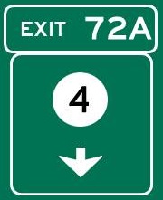
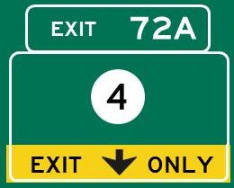
Exit 72A -
Milepost 121.7
Englewood
Fair Lawn
Paramus via NJ 17 North
Teaneck
|
Continue west on 
|
EXIT 72A
Directions
ENGLEWOOD
 Bergen Performing Arts Center, 3 miles north Bergen Performing Arts Center, 3 miles north
Black Box Performing Arts Center, 2 3/4 miles north
Flat Rock Brook Nature Association, 1 1/2 miles north
 Xtreme Energy, 2 1/2 miles NW Xtreme Energy, 2 1/2 miles NW
TENAFLY
Tenafly Nature Center, 6 miles north
SMA African Art Museum, 4 miles north
|
|
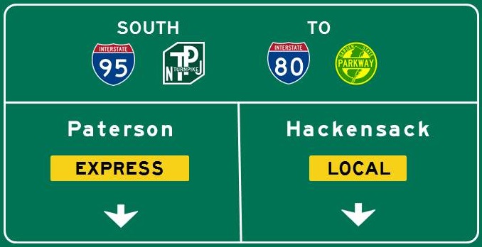
Lanes Split -
Milepost 121.7
All lanes through to I-95 and I-80
I-95 Local
All I-95 Exits
Bogota
Leonia
Teaneck
I-95 Express
First exit is Exit 69
Ridgefield Park
I-80 Local
All I-80 Exits
Hackensack
Hasbrouck Heights
Little Ferry
South Hackensack
Teterboro
NJ 17
Teterboro Airport
I-80 Express
First exit is Exit 63
Elmwood Park
Lodi
Paterson
Rochelle Park
Garden State Parkway
|
|
|
|
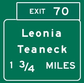
Exit 70 -
Milepost 119.7
Bogota
Leonia
Teaneck
|
Local only
|
EXIT 70
Directions
LEONIA
 Field Station: Dinosaurs, 1 3/4 miles NE Field Station: Dinosaurs, 1 3/4 miles NE
TEANECK
Teaneck Creek Conservancy, 3/4 mile NW
Teaneck Speedway, 2 1/4 miles NW
|
|
Exit 69 -
Milepost 119.5
Elmwood Park
Hackensack
Hasbrouck Heights
Little Ferry
Lodi
Paterson
Rochelle Park
South Hackensack
Teterboro
Garden State Parkway
Teterboro Airport
|
Express and Local

Continue west on 
|
EXIT 69
Directions
HACKENSACK
Hackensack Performing Arts Center, 2 1/2 miles NW
|
|
|
Express and local lanes merge - Milepost 119.2
|
|
|
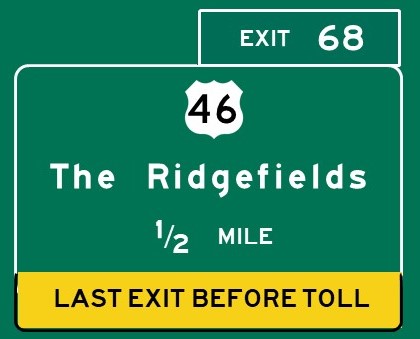
Exit 68 -
Milepost 118.9
US 46 East
Ridgefield
US 46 West
Little Ferry
Moonachie
Ridgefield Park
|
Continue east / west on
|
EXIT 68
Directions
TETERBORO
Aviation Hall of Fame of New Jersey, 2 1/4 miles west
|
|
|
Turnpike Divides - Milepost 117.1
Eastern Spur - Exits 17, 15X, 15W, 15E
Western Spur - Exits 19W, 16W, 15W, 15E
|
|
|
Vince Lombardi
Service Area
Dunkin' Donuts
EVGo Charging Station
Popeye's
Pret-a-Manger
Shake Shack
Sunoco
Travel Mart
Vending Machines
Park and Ride to NYC
|
Vince Lombardi Service Area
Milepost E116.0
|
|
|
|
Tolled section of New Jersey Turnpike and  begins begins
|
|
|
EXIT 17 -
Milepost E113.7
NJ 495 East
Hoboken
Midtown Manhattan
Union City
Weehawken
Lincoln Tunnel
NJ 3 West
Secaucus
|

Continue west on 
|
EXIT 17
Directions
HOBOKEN
Gravity Vault, 2 3/4 miles SE
Hoboken Fire Department Museum, 4 miles SE
Hoboken Historical Museum, 3 miles SE
Mile Square Theatre, 3 miles SE
JERSEY CITY
Mana Contemporary, 3 3/4 miles south
NORTH BERGEN
Helix eSports, 1 1/4 miles east
 New Jersey Beer Co., 1 1/4 miles east New Jersey Beer Co., 1 1/4 miles east
SECAUCUS
Secaucus Town Museum, 1/2 mile NW
|
|
|
Toll Plaza - Milepost E112.5
All lanes accept EZ Pass
Some lanes are EZ Pass only
|
|
|
Alexander Hamilton
Service Area
A-Plus Store
Starbucks
Sunoco
|
Alexander Hamilton Service Area
Milepost E111.6
|
|
|
EXIT 15X -
Milepost E111.0
Secaucus
Frank R Lautenberg
Secaucus Station
|

|
|
|
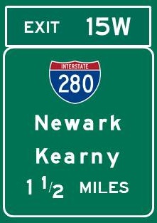
EXIT 15W -
Milepost E109.0
Harrison
Kearny
Livingston
Newark
The Oranges
Parsippany-Troy Hills
New Jersey Institute
of Technology
Red Bull Arena
Rutgers University - Newark
UMDNJ
|
Continue west on 
|
EXIT 15W
Directions
KEARNY
Kearny Museum, 2 miles west
NEWARK
Jewish Museum of New Jersey, 4 1/2 miles west
New Jersey Historical Society, 4 miles SW
New Jersey Performing Arts Center, 3 1/2 miles SW
Newark Museum of Art, 3 1/2 miles SW
Paul Robeson Galleries, 4 1/4 miles SW
|
|
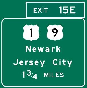
EXIT 15E -
Milepost E107.3
No access to Pulaski Skyway
Jersey City
Newark
Prudential Center
South Kearny Industrial Area
|
Continue south on
Continue south on
|
|
|
|
Continue here on Turnpike Mainline
|
|
|
|
Western Spur - Exits 19W, 16W, 15W, 15E
|
|
|
Vince Lombardi
Service Area
Dunkin' Donuts
EVGo Charging Station
Popeye's
Pret-a-Manger
Shake Shack
Sunoco
Travel Mart
Vending Machines
Park and Ride to NYC
|
Vince Lombardi Service Area
Milepost W115.5
|
|
|
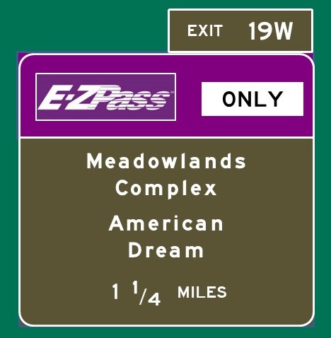
EXIT 19W -
Milepost W114.6
EZ Pass only -
Car toll $1.95
American Dream Complex
Meadowlands Sports Complex
Meadowlands Arena
Meadowlands Racetrack
MetLife Stadium
|
|
EXIT 19W
EAST RUTHERFORD
American Dream Complex, direct access from exit
DreamWorks Water Park
LEGOLAND Discovery Center
Nickelodeon Universe
Sea Life Aquarium
TiLT Museum
|
|
|
Tolled section of New Jersey Turnpike and begins
|
|
|
|
Toll Plaza - Milepost W113.8
All lanes accept EZ Pass
EZ Pass Express lanes, keep left
Vehicles without EZ Pass, keep right
|
|
|
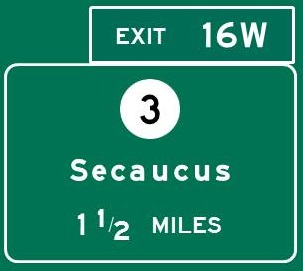
EXIT 16W -
Milepost W113.1
NJ 3 West
Lyndhurst
Nutley
Rutherford
NJ 3 East
Secaucus
Meadowlands Arena
Direct access to
Meadowlands Racetrack
MetLife Stadium
|
Continue east / west on
|
EXIT 16W
Directions
CARLSTADT
Bolero Snort Brewery, 3 miles north
LYNDHURST
Meadowlands Environment Center, 4 miles SW
RUTHERFORD
Meadowlands Museum, 2 miles west
SECAUCUS
Secaucus Town Museum, 1 1/4 miles SE
|
|
EXIT 15W -
Milepost W109.0
Harrison
Kearny
Livingston
Newark
The Oranges
Parsippany-Troy Hills
New Jersey Institute
of Technology
Red Bull Arena
Rutgers University - Newark
UMDNJ
|

Continue west on
|
EXIT 15W
Directions
KEARNY
Kearny Museum, 2 miles west
NEWARK
Jewish Museum of New Jersey, 4 1/2 miles west
New Jersey Historical Society, 4 miles SW
New Jersey Performing Arts Center, 3 1/2 miles SW
Newark Museum of Art, 3 1/2 miles SW
Paul Robeson Galleries, 4 1/4 miles SW
|
|
EXIT 15E -
Milepost W107.2
No access to Pulaski Skyway
Jersey City
Newark
Prudential Center
South Kearny Industrial Area
|
Continue south on
Continue south on
|
|
|
Dual carriageways begin - Milepost 106.5
|
Mainline resumes
Turnpike splits into Cars Only and All Vehicles carriageways.
Traffic for Exits 14, 14A, 14B and 14C should keep right.
|
|
|
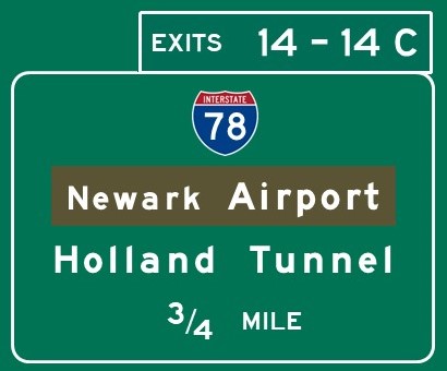
EXIT 14 -
Milepost 106.1
Use truck lanes for Exit 14
I-78 East
Bayonne
Jersey City
Lower Manhattan -
Financial District
Holland Tunnel
I-78 West
Hillside
Irvington
Newark
Union
US 1-9 South
Newark Liberty Int'l Airport
|
Continue east / west on 
Continue north / south on
Continue north / south on
Continue west on 
|
EXIT 14
Directions
NEWARK
All Points West Distillery, 3 miles NW
|
|
EXIT 13A -
Milepost 102.0
Elizabeth via US 1-9 South
Elizabeth Seaport
Jersey Gardens Mall
Kean University via NJ 439
Newark Liberty Int'l Airport
via US 1-9 North
|

|
EXIT 13A
Directions
UNION
Galleries at Kean University, 2 3/4 miles west
Kean Stage, 2 1/4 miles west
Liberty Hall, 2 1/2 miles west
|
|
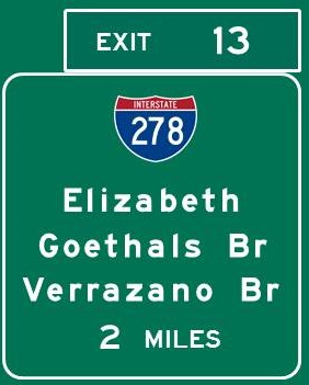
EXIT 13 -
Milepost 99.9
I-278 East
Brooklyn NY
Staten Island NY
Goethals Bridge
Verrazano Bridge
I-278 West
Linden
Westfield
NJ 439
Elizabeth
|
|
EXIT 13
Directions
ELIZABETH
Boxwood Hall, 2 1/4 miles north
Ritz Theatre and Performing Arts Center,
1 3/4 miles north
|
|
EXIT 12 -
Milepost 96.4
Carteret
Rahway
|

|
EXIT 12
Directions
RAHWAY
Merchants and Drovers Tavern, 4 miles NW
Union County Performing Arts Center, 3 3/4 miles NW
WOODBRIDGE
Avenel Performing Arts Center, 4 miles SW
Barron Arts Center, 4 3/4 miles SW
|
|
Thomas Edison
Service Area
A-Plus Market
Auntie Anne's
Burger King
Chick-fil-A
Pret-a-Manger
Starbucks
Sunoco
Vending Machines
Z Market
|
Thomas Edison Service Area
Milepost 92.9
|
|
|
EXIT 11 -
Milepost 91.8
Garden State Parkway North
Exits 131-172
Menlo Park
Woodbridge
Woodbridge Center Mall
Garden State Parkway South
Exits 124-0
Asbury Park
Atlantic City
Freehold
Lakewood
Long Beach Island
Shore Resorts
Toms River
US 9 South
Perth Amboy
via New Brunswick Ave.
|

Continue north / south on 
Continue north / south on
|
EXIT 11
Directions
EDISON
Thomas Edison Center at Menlo Park, 3 1/2 miles NW
PERTH AMBOY
Kearny Cottage, 3 3/4 miles SE
Proprietary House, 3 3/4 miles SE
WOODBRIDGE
 SeaQuest Woodbridge, 3 1/4 miles north SeaQuest Woodbridge, 3 1/4 miles north
|
|
EXIT 10 -
Milepost 88.7
I-287 North
Edison
Metuchen
Piscataway
Somerville
South Plainfield
NJ 440 North
Perth Amboy
Staten Island NY
Outerbridge Crossing
|

Continue north on 
Continue north on 
|
EXIT 10
Directions
EDISON
Cypress Brewing Co., 3 miles SW
Supercharged Entertainment, 2 1/4 miles SW
SAYREVILLE
Sayreville Historical Society Museum, 6 1/2 miles south
|
|
EXIT 9 -
Milepost 84.0
NJ 18 North
To US 1
Highland Park
via NJ 27 North
Milltown via US 1 South
New Brunswick
North Brunswick
via US 1 South
Princeton via US 1 South
High Point Solutions Stadium
Princeton University
via US 1 South
Robert Wood Johnson
University Hospital
Rutgers University
St. Peter's University Hospital
NJ 18 South
East Brunswick
Old Bridge
Sayreville
South River
|

Continue north / south on 
|
EXIT 9
Directions
EAST BRUNSWICK
Crystal Springs Family Waterpark, 6 1/2 miles SW
East Brunswick Museum, 5 1/4 miles SE
The Jumping Jungle, 2 1/2 miles south
Playhouse 22, 6 1/2 miles SW
Pups of War, 4 miles south
Rock 'N' Air Adventure Park, 3 miles south
FRANKLIN TOWNSHIP
Villagers Theatre, 8 1/4 miles NW
KINGSTON
Rockingham State Historic Site, 14 3/4 miles SW
MILLTOWN
Urban Air Adventure Park, 4 miles south
NEW BRUNSWICK
Hungarian Heritage Center, 2 1/2 miles north
New Brunswick Performing Arts Center, 2 1/2 miles NW
Rutgers University Geology Museum, 3 miles north
State Theatre, 3 miles west
Jane Voorhees Zimmerli Art Museum, 3 miles NW
NORTH BRUNSWICK
Rutgers Gardens, 1 1/2 miles SW
OLD BRIDGE
Main Street Theatre Co., 6 miles SE
PISCATAWAY
East Jersey Old Town, 5 miles NW
Cornelius Low House/Middlesex County Museum,
5 miles NW
Rutgers University Ecological Preserve, 5 3/4 miles NW
PRINCETON
Herrontown Woods, 15 1/2 miles SW
Institute Woods, 20 miles SW
McCarter Theatre Center, 18 miles SW
Morven Museum and Gardens, 19 miles SW
Princeton Battlefield State Park, 20 miles SW
Princeton University Art Museum, 18 1/2 miles SW
Updike Farmstead, 22 miles south
|
|
EXIT 8A -
Milepost 74.2
NJ 32 East
Englishtown
Jamesburg
Monroe Township
(Middlesex Co.)
NJ 32 West/US 130 South
Cranbury
Plainsboro
NJ 32 West/US 130 North
South Brunswick
|

Continue north / south on 
|
EXIT 8A
Directions
CRANBURY
Cranbury Museum, 3 1/4 miles SW
PLAINSBORO
Historic Wicoff House Museum, 7 1/4 miles west
Plainsboro Preserve, 5 miles west
|
|
Molly Pitcher
Service Area
Applegreen
EVGo/Tesla Charging Stations
Panda Express
Shake Shack
Starbucks
Subway
Sunoco
Vending Machines
|
Molly Pitcher Service Area
Milepost 71.7
|
|
|
EXIT 8 -
Milepost 68.0
NJ 33 East
Freehold
Manalapan
NJ 33 West
East Windsor
Hightstown
NJ 133 West
West Windsor
|

Continue east / west on 
|
EXIT 8
Directions
HIGHTSTOWN
Old Hights Brewing Co., 1 1/2 miles west
MANALAPAN
Monmouth Battlefield State Park, 9 1/2 miles east
ROBBINSVILLE
Working Dog Winery, 4 miles SW
WEST WINDSOR
Kelsey Theatre at Mercer, 9 1/4 miles west
|
|
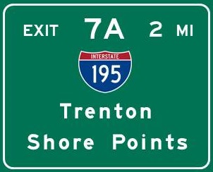
EXIT 7A -
Milepost 61.5
I-195 East
Allentown
Belmar
Point Pleasant
I-195 West
Hamilton Township
Trenton
Arm and Hammer Stadium
The College of New Jersey
Rider University
|
Continue east / west on 
|
EXIT 7A
Directions
HAMILTON
Civil War and Native American Museum,
4 1/2 miles west
Grounds for Sculpture, 11 3/4 miles NW
Kuser Farm Mansion, 7 miles west
Rockville Climbing Center, 12 1/4 miles NW
Sayen Gardens, 5 1/2 miles NW
JACKSON
Six Flags Great Adventure, 11 1/4 miles east
PLUMSTED TOWNSHIP
Laurita Winery, 14 miles SE
ROBBINSVILLE
Oasis Family Farm, 1 3/4 miles south
TRENTON
Artworks, 10 1/2 miles west
Ellarslie, 12 miles west
New Jersey State House, 10 3/4 miles west
New Jersey State Museum, 10 3/4 miles west
Old Barracks Museum, 10 3/4 miles west
Passage Theatre, 10 1/2 miles west
William Trent House, 10 miles west
UPPER FREEHOLD TOWNSHIP
Cream Ridge Winery, 5 miles SE
Historic Walnford, 6 1/4 miles SE
Screamin' Hill Brewery, 9 miles SE
Union Transportation Trail
Herbert Rd. Parking Area, 5 miles NE
Millstream Rd. Parking Area, 10 miles SE
WEST TRENTON
New Jersey State Police Museum, 15 1/2 miles NW
|
|
Richard Stockton
Service Area
Auntie Anne's
Burger King
Dunkin' Donuts
Nathan's
Sunoco
Tesla Charging Station
Vending Machines
Z Market
|
Richard Stockton Service Area
Milepost 58.7
|
|
|
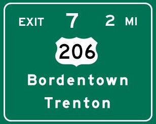
EXIT 7 -
Milepost 54.2
US 206 North
Bordentown
Trenton
US 206 South
Eastampton Township
Mansfield Township
Pemberton
Wrightstown via NJ 68
Columbus Farmers Market
Joint Base MDL via NJ 68
|
Continue north / south on 
|
EXIT 7
Directions
BORDENTOWN
Pegasus Theatre Company, 2 miles north
CHESTERFIELD
Fernbrook Farms Environmental Education Center,
3 1/4 miles SE
Fundaes Arcade, 3 3/4 miles east
EASTAMPTON
Smithville Mansion, 10 miles south
Underground Railroad Museum of New Jersey,
10 miles south
Worker's House and Gallery, 10 miles south
MANSFIELD TOWNSHIP
Iron Plow Vineyards, 5 3/4 miles SE
SPRINGFIELD TOWNSHIP
Howlers Hatchet House, 5 1/2 miles south
Recklesstown Farm Distillery, 6 miles south
|
|
EXIT 6 -
Milepost 51.7
Florence
Harrisburg PA
Levittown PA
Norristown PA
Philadelphia PA
Pennsylvania Turnpike
|

Multiplex with ends
|
EXIT 6
Directions
FLORENCE
Roebling Museum, 4 1/4 miles NW
|
|
|
Car and truck lanes merge - Milepost 49.0
|
|
|
EXIT 5 -
Milepost 44.6

Co. Rt. 541 North
Burlington
Willingboro
Burlington-Bristol Bridge
Co. Rt. 541 South
Mount Holly
Westampton Township
|

|
EXIT 5
Directions
BURLINGTON
Burlington County Historical Society, 4 miles north
Lyceum Hall Center for the Arts, 4 miles north
Third State Brewing, 4 1/4 miles north
LUMBERTON
Air Victory Museum, 8 1/4 miles south
MEDFORD
Dr. James Still Historic Office Site, 8 1/2 miles south
MOORESTOWN
Boundary Creek Natural Resource Area,
8 1/4 miles west
MOUNT HOLLY
Burlington Co Lyceum of History and Natural Sciences,
2 1/2 miles south
Burlington County Prison-Museum, 2 1/2 miles south
Spellbound Brewing, 3 3/4 miles south
Train Wreck Distillery, 3 1/4 miles south
Village Idiot Brewing Co., 2 3/4 miles south
Warden's House Gallery, 2 1/2 miles south
RIVERSIDE
Riverside Historical Society, 12 miles west
WESTAMPTON
Rancocas Nature Center, 3 1/2 miles south
Rancocas State Park, 2 3/4 miles SW
|
|
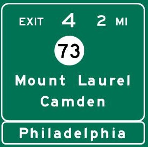
EXIT 4 -
Milepost 34.9
NJ 73 North
Camden via NJ 38 West
Cherry Hill via I-295 South
Collingswood via NJ 38 West
Haddonfield via I-295 South
Maple Shade
Moorestown via NJ 38 East
Mount Laurel
Palmyra
Philadelphia PA Center City
via NJ 38 West
Ben Franklin Bridge
via NJ 38 West
Betsy Ross Bridge via NJ 90
Tacony-Palmyra Bridge
Woodcrest PATCO Station
via I-295 South
NJ 73 South
Berlin
Marlton
|
Continue north / south on 
|
EXIT 4
Directions
BERLIN
Berlin Brewing Co., 10 1/2 miles south
Big Kahuna's, 8 1/2 miles south
Diggerland, 8 3/4 miles south
CAMDEN
Adventure Aquarium, 10 1/4 miles west
Camden County Historical Society Museum,
8 miles west
Rutgers-Camden Center for the Arts/Stedman Gallery,
9 3/4 miles west
USS New Jersey Battleship Museum, 10 1/4 miles west
Walt Whitman House State Historic Site,
9 3/4 miles west
CHERRY HILL
Barclay Farmstead, 3 1/2 miles SW
The Big Event, 4 1/2 miles SW
Bury the Hatchet, 2 1/4 miles south
Escape Virtual Reality, 4 miles south
Forgotten Boardwalk Brewing, 1 3/4 miles SW
Mechanical Brewery, 4 miles SW
CINNAMINSON
K1 Speed, 7 1/4 miles NW
CLEMENTON
Clementon Park and Splash World, 12 miles SE
COLLINGSWOOD
Perkins Center for the Arts
Collingswood facility, 8 miles west
Scottish Rite Auditorium, 8 3/4 miles west
EVESHAM TOWNSHIP
Black Run Preserve, 7 miles SE
HADDONFIELD
Greenfield Hall, 7 miles SW
Haddonfield Plays and Players, 8 1/2 miles SW
Indian King Tavern State Historic Site, 6 3/4 miles SW
King's Road Brewing Co., 7 miles SW
Markeim Arts Center, 6 3/4 miles SW
LAWNSIDE
Peter Mott House, 7 1/4 miles SW
MAPLE SHADE
Elite Climbing, 2 1/2 miles NW
Sky Zone Trampoline Park, 1 mile north
MARLTON
Center for the Arts in Southern New Jersey, 5 miles SW
MEDFORD
Medford Arts Center, 7 3/4 miles east
Woodford Cedar Run Wildlife Refuge, 11 miles SE
MERCHANTVILLE
Eclipse Brewing Co., 5 1/2 miles west
MOORESTOWN
Family Virtual Fun Zone, 1 1/2 miles north
Perkins Center for the Arts
Moorestown facility, 2 1/2 miles north
Smith-Cadbury Mansion, 11 miles SW
MOUNT LAUREL
Coco Key Water Resort, 1/2 mile north
The Funplex, 6 miles NE
Paulsdale, 2 3/4 miles NE
PALMYRA
Palmyra Cove Nature Park, 7 miles NW
PENNSAUKEN
Double Nickel Brewing Co., 5 3/4 miles NW
SOMERDALE
Armageddon Brewing Co., 9 miles SW
Flying Fish Brewery, 9 miles SW
VOORHEES
Gravity Vault, 7 3/4 miles SW
|
|
Walt Whitman
Service Area
|
Walt Whitman Service Area
Milepost 30.2
Temporarily closed - no services
|
|
|
EXIT 3 -
Milepost 26.5
NJ 168 North
Barrington
Bellmawr
Bridgeton via I-295 South/
NJ 42 South/NJ 55 South
Camden via I-295 South/
I-76 West/I-676 North
Glassboro via I-295 South/
NJ 42 South/NJ 55 South
Gloucester City
via I-295 South
Millville via I-295 South/
NJ 42 South/NJ 55 South
Philadelphia - South Phila
via Walt Whitman Br
Pitman via I-295 South/
NJ 42 South/NJ 55 South
Vineland via I-295 South/
NJ 42 South/NJ 55 South
Woodbury via I-295 South
Atlantic City Expressway
via I-295 South/NJ 42 South
Rowan University
via I-295 South/
NJ 42 South/NJ 55 South
Schuylkill Expressway
via Walt Whitman Br
Walt Whitman Bridge
via I-295 South/I-76 West
NJ 168 South
Mount Ephraim
Runnemede
|

Continue north / south on 
|
EXIT 3
Directions
CAMDEN
Camden Shipyard and Maritime Museum,
5 1/2 miles north
South Camden Theatre Co., 5 1/2 miles NE
DEPTFORD
Museum of American History, 5 1/2 miles west
GLASSBORO
Bonesaw Brewing Co., 14 miles south
Heritage Glass Museum, 15 3/4 miles south
Rowan University Art Gallery, 15 miles south
Summit City Farms and Winery, 14 3/4 miles south
HADDON HEIGHTS
Tanner Brewing Co., 2 1/2 miles NE
HADDON TOWNSHIP
Ritz Theatre Company, 3 1/2 miles NE
NATIONAL PARK
Red Bank Battlefield/James and Ann Whitall House,
8 miles SW
OAKLYN
Tonewood Brewing, 3 1/2 miles north
PITMAN
Broadway Theatre of Pitman, 12 1/4 miles south
WOODBURY
Hunter-Lawrence-Jessup House, 7 miles SW
|
|
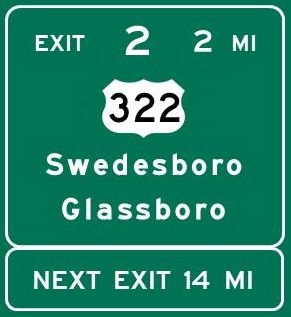
EXIT 2 -
Milepost 13.2
US 322 East
Glassboro
Harrison Township
Mullica Hill
US 322 West
Chester PA
Swedesboro
Woodstown via NJ 45 South
Woolwich Township
Commodore Barry Bridge
|
Continue east / west on 
|
EXIT 2
Directions
LOGAN TOWNSHIP
Cedarvale Winery, 5 1/4 miles NE
MULLICA HILL
Old Town Hall Museum, 3 1/2 miles east
PEDRICKTOWN
Salem Oak Vineyards, 9 miles west
PILESGROVE
Cowtown Rodeo, 9 1/2 miles SW
Auburn Road Vineyard and Winery, 10 1/4 miles SW
RICHWOOD
William Heritage Winery, 6 miles east
SOUTH HARRISON TOWNSHIP
Wagonhouse Winery, 6 miles south
SWEDESBORO
Swedesboro Brewing Co., 3 1/4 miles SW
WOODSTOWN
Farmers & Bankers Brewing Co., 9 1/2 miles south
Pilesgrove-Woodstown Historical Society Museum,
9 1/2 miles south
WOOLWICH TOWNSHIP
DiBella Winery, 4 miles SW
Independent Spirits Distillery, 4 1/4 miles SW
|
|
Clara Barton
Service Area
Auntie Anne's
Burger King
Cinnabon
Pizza Hut Express
Starbucks
Sunoco
Tesla Charging Station
Travel Mart
Vending Machines
|
Clara Barton Service Area
Milepost 5.4
|
|
|
|
Toll Plaza - Milepost 2.6
All lanes accept EZ Pass
EZ Pass Express lanes, keep left
Vehicles without EZ Pass, keep right
|
|
|
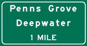
Penns Grove/
Deepwater Exit -
Milepost 1.2
Carneys Point
Deepwater
Penns Grove
|
|
Penns Grove/Deepwater Exit
Directions
HANCOCKS BRIDGE
Hancock House State Historic Site, 13 1/2 miles south
PENNS GROVE
His Soc of Penns Grove, Carneys Pt and Oldmans Mus,
4 miles north
SALEM
Salem County Historical Society Museum,
8 3/4 miles south
|
|
|
Continue here on  South South
|
|
|
Home
|
|

