|
Home
|

|
|
EXIT 1A
Bordentown
Burlington
Camden
Haddonfield
Moorestown
Paulsboro
Woodbury
Delaware Memorial Bridge
EXIT 1B
Lawrence Township
New Brunswick via US 1
Princeton via US 1
|

Continue north / south on 
|
EXIT 1A
Directions
HAMILTON
 Abbott Marshlands, Abbott Marshlands,
D&R Canal Paths, 1 1/4 miles south
EXIT 1B
Directions
HAMILTON
Abbott Marshlands,
Nature Center/Roebling Park, 3 miles NW
|
|
EXIT 1C
Bordentown
Burlington via US 130 South
Hammonton
Mount Holly
|

Continue south on 
|
EXIT 1C
Directions
BORDENTOWN
Abbott Marshlands,
Bordentown Beach, 3 miles SW
Bordentown Bluffs, 1 3/4 miles south
Northern Community Park, 2 miles SE
|
|
EXIT 1D
Hamilton Township
(Mercer County)
Mercerville
White Horse
|

Continue north on
|
|
|
EXIT 2
Yardville
|

|
|
|
Exit 3A
Yardville
Exit 3B
Hamilton Square
Hamilton Township
(Mercer County)
Robert Wood Johnson
University Hospital
|

|
EXIT 3B
Directions
 Civil War and Native American Museum, Civil War and Native American Museum,
1 1/2 miles west
Sayen Gardens, 3 miles north
|
|
Exit 5A
Bordentown
Burlington
Florence
Burlington-Bristol Bridge
Hamilton Marketplace
Exit 5B
Cranbury
East Windsor Township
Hightstown
New Brunswick
North Brunswick Township
Robbinsville
South Brunswick Township
Rutgers University
|

Continue north / south on 
|
|
|
EXIT 6
New Jersey Turnpike North
Exits 8-18
Elizabeth
Fort Lee
Hightstown
Jersey City
New Brunswick
New York City
Newark
Woodbridge
Rutgers University
New Jersey Turnpike South
Exits 7-1
Burlington
Camden
Cherry Hill
Mount Holly
Philadelphia PA
Woodbury
Delaware Memorial Bridge
|

Continue north / south on  
|
|
|
EXIT 7
Co. Rt. 526 East
Allentown
Cream Ridge via Co. Rt. 539
Upper Freehold Township
Co. Rt. 526 West
Robbinsville
|

|
EXIT 7
Directions
NEW EGYPT
New Egypt Museum, 9 miles south
ROBBINSVILLE
 Oasis Family Farm, 1 mile west Oasis Family Farm, 1 mile west
UPPER FREEHOLD TOWNSHIP
 Cream Ridge Winery, 4 miles SE Cream Ridge Winery, 4 miles SE
 Historic Walnford, 5 1/4 miles SE Historic Walnford, 5 1/4 miles SE
Union Transportation Trail
Millstream Rd. Parking Area, 8 1/2 miles SE
|
|
EXIT 8
Co. Rt. 539 North
East Windsor Township
Hightstown
Co. Rt. 539 South
Allentown
New Egypt
Tuckerton
Upper Freehold Township
Whiting
|

|
EXIT 8
Directions
PLUMSTED TOWNSHIP
Laurita Winery, 12 miles south
ROBBINSVILLE
Working Dog Winery, 4 1/2 miles NE
UPPER FREEHOLD TOWNSHIP
Union Transportation Trail
Herbert Rd. Parking Area, 3 miles NE
|
|
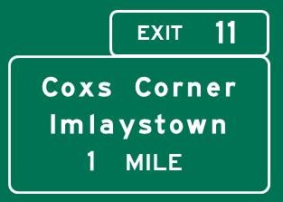
EXIT 11
Coxs Corner
Imlaystown
Upper Freehold Township
|
|
EXIT 11
Directions
UPPER FREEHOLD TOWNSHIP
Screamin' Hill Brewery, 3 1/2 miles SE
|
|
EXIT 16A
Mount Holly
New Egypt
Wrightstown
Joint Base MDL
Fort Dix
McGuire AFB
Virtua Memorial Hospital
EXIT 16B
Freehold Borough
Freehold Township
Millstone Township
Roosevelt
CentraState Medical Center
Jackson Premium Outlets
|

|
EXIT 16A
Directions
JACKSON
Six Flags Great Adventure, 1 mile west
EXIT 16B
Directions
MANALAPAN
Monmouth Battlefield State Park, 10 miles NE
|
|
Exit 21
Co. Rt. 527 North
Freehold Township
Siloam
Co. Rt. 527 South
Jackson Township
Joint Base MDL
Lakehurst Naval Air Station
To Co. Rt. 526
|

|
EXIT 21
Directions
JACKSON
 Forest Resource Education Center, 4 1/2 miles south Forest Resource Education Center, 4 1/2 miles south
|
|
Exit 22
Freehold Township
Georgia
Jackson Mills
Jackson Township
|

|
EXIT 22
Directions
FREEHOLD TOWNSHIP
Turkey Swamp Park, 3 3/4 miles north
LAKEWOOD
Lakewood Historical Museum, 5 1/2 miles SE
|
|
Exit 28A
Howell Township
Lakewood
Toms River
First Energy Park
Exit 28B
Freehold
Howell Township
|

Continue north / south on 
|
EXIT 28A
Directions
HOWELL TOWNSHIP
ClimbZone, 2 1/2 miles south
LAKEWOOD
Sister Mary Grace Burns Arboretum, 4 3/4 miles south
 Strand Center for the Arts, 5 miles south Strand Center for the Arts, 5 miles south
EXIT 28B
Directions
FREEHOLD
Covenhoven House, 6 3/4 miles NW
Jewish Heritage Museum of Monmouth County,
8 1/4 miles NW
Monmouth County Historical Association Museum,
7 1/2 miles north
HOWELL TOWNSHIP
Manasquan Reservoir Environmental Center
Visitor Center, 2 miles east
Environmental Center, 1 1/4 miles NE
Seven Sons Brewing, 2 miles north
Swingtime, 2 1/2 miles NW
|
|
Exit 31A
Co. Rt. 547 South
Howell Township
Lakewood
Co. Rt. 549 East
Brick Township
Point Pleasant
Exit 31B
Co. Rt. 524 West/
Co. Rt. 547 North
Farmingdale
Howell Township
Co. Rt. 524 East
Wall Township
|

|
EXIT 31B
Directions
WALL TOWNSHIP
Allaire State Park, 1 1/2 miles east
New Jersey Museum of Transportation, 1 1/2 miles east
|
|
Exit 35A
NJ 34 South
Brielle
Manasquan
Point Pleasant
Wall Township
Garden State Parkway South
Exits 91-0
Atlantic City
Cape May
Toms River
Exit 35B
NJ 34 North
Colts Neck Township
Matawan
Wall Township
Earle NWS
Monmouth Executive Airport
Wall Stadium Speedway
|

Continue south on 
Continue north / south on 
|
|
|
Exit 36
Garden State Parkway North
Exits 100-172
Elizabeth
New York City
Newark
Paterson
Perth Amboy
Ridgewood
Woodbridge
|

Continue north on
|
|
|
Continue on NJ 138
Belmar
Lake Como
Spring Lake
Wall Township
|

|
NJ 138 EAST
Directions
Old Wall Historical Society, 2 3/4 miles east
|
|
|
Home
|
|
