|
Home
|

|
|
EXIT 1A
Bridgeton
Millville
Pennsville
Salem
|

Continue east on 
|
EXIT 1A
Directions
PENNSVILLE
 Church Landing Farm Museum, 1 mile west Church Landing Farm Museum, 1 mile west
 Fort Mott State Park, 6 1/2 miles SW Fort Mott State Park, 6 1/2 miles SW
 Supawna Meadows National Wildlife Refuge, Supawna Meadows National Wildlife Refuge,
5 1/4 miles south
|
|
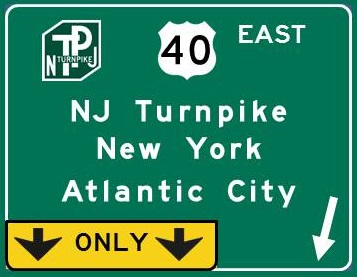
NJ Turnpike-US 40 - Delaware Milepost 5.0
NJ Turnpike
Elizabeth
Jersey City
New Brunswick
New York City
Newark
US 40 East
Atlantic City
Hammonton
Mays Landing
Vineland
Woodstown
|
Continue north on  Continue east on
|
US 40 EAST
Directions
PILESGROVE TOWNSHIP
 Auburn Road Vineyard and Winery, 7 1/4 miles east Auburn Road Vineyard and Winery, 7 1/4 miles east
 Cowtown Rodeo, 6 miles east Cowtown Rodeo, 6 miles east
WOODSTOWN
Pilesgrove-Woodstown Historical Society Museum,
9 miles east
|
|
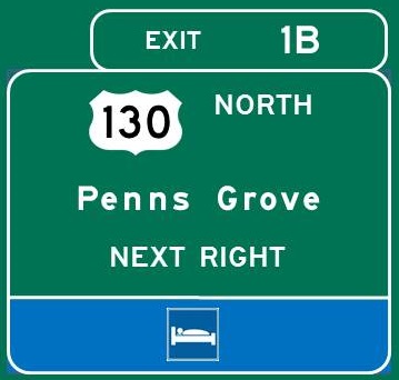
EXIT 1B
Carneys Point Township
Deepwater
Penns Grove
|
Continue north on 
|
|
|
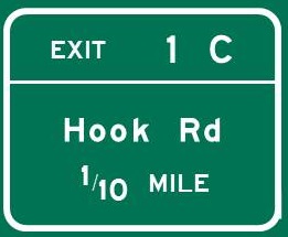
EXIT 1C
Salem
Pennsville bypass to
Bridgeton
|
|
EXIT 1C
Directions
HANCOCK'S BRIDGE
 Hancock House, 12 1/2 miles south Hancock House, 12 1/2 miles south
SALEM
Salem County Historical Society Museum, 8 miles south
Tadmore Distilling Co., 7 3/4 miles south
|
|
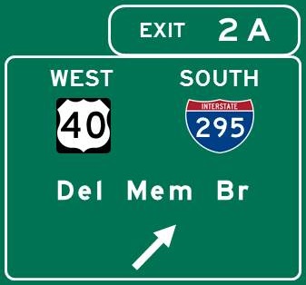
EXIT 2A
Delaware Memorial Bridge
|
Continue south on 
Continue west on
|
|
|
EXIT 2B
US 40 East
Woodstown
Vineland
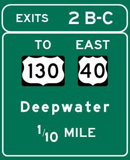
EXIT 2C
Carneys Point Township
Deepwater
To US 130
|
Continue north / south on
Continue east on
|
|
|
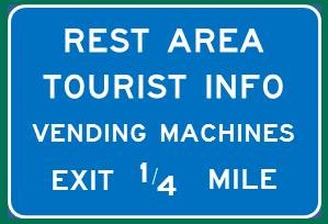
Welcome Center -
Milepost 2.3
|
|
|
|
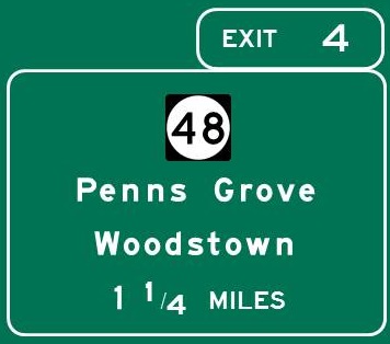
EXIT 4
NJ 48 East
Carneys Point Township
Penns Grove
NJ 48 West
Pilesgrove Township
Woodstown
|
|
EXIT 4
Directions
PENNS GROVE
Hist Soc of Penns Grove, Carneys Pt and Oldmans Mus,
2 1/4 miles west
|
|
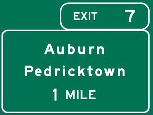
EXIT 7
Auburn
Oldmans Township
Pedricktown
|
|
EXIT 7
Directions
OLDMANS TOWNSHIP
Salem Oak Vineyards, 2 3/4 miles north
|
|
EXIT 10
Logan Township
Swedesboro
Woolwich Township
Gloucester County
Dream Park
|

|
EXIT 10
Directions
SWEDESBORO
Swedesboro Brewing Co., 3 miles SE
WOOLWICH TOWNSHIP
DiBella Winery, 4 1/2 miles SE
Independent Spirits Distillery, 4 miles SE
|
|
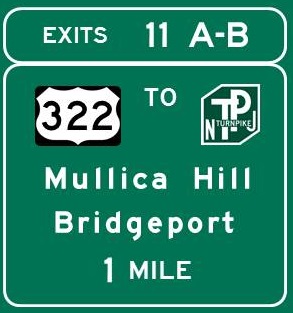
EXIT 11A
US 322 East
Atlantic City
Glassboro
Mays Landing
Mullica Hill
Pitman
Richwood
Williamstown
Woolwich Township
New Jersey Turnpike
EXIT 11B
US 322 West
Bridgeport
Chester PA
Logan Township
Commodore Barry Bridge
|
Continue east / west on 
|
EXIT 11A
Directions
GLASSBORO
Heritage Glass Museum, 13 3/4 miles SE
 Rowan University Art Gallery, 13 miles SE Rowan University Art Gallery, 13 miles SE
Summit City Farms and Winery, 12 3/4 miles SE
MULLICA HILL
Old Town Hall Museum, 7 1/2 miles SE
PITMAN
Broadway Theatre of Pitman, 12 3/4 miles east
|
|
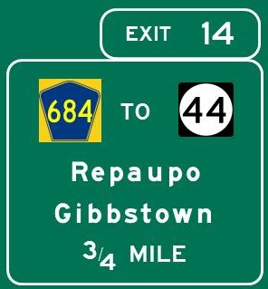
EXIT 14
Gibbstown
Logan Township
Repaupo
Bridgeport Speedway
|
|
EXIT 14
Directions
LOGAN TOWNSHIP
Cedarvale Winery, 1/2 mile NW
|
|
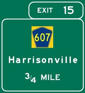
EXIT 15
Gibbstown
Greenwich Township
Harrisonville
|
|
|
|
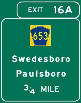
EXIT 16A
Gibbstown
Greenwich Township
Paulsboro
Swedesboro
|
|
|
|
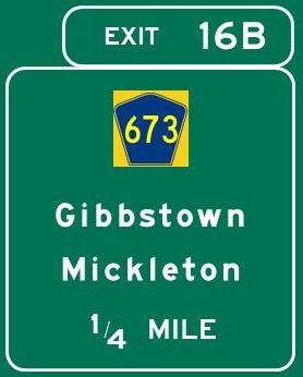
EXIT 16B
East Greenwich Township
Gibbstown
Greenwich Township
Mickleton
|
|
|
|
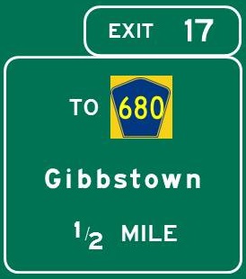
EXIT 17
East Greenwich Township
Gibbstown
Greenwich Township
Mickleton
Paulsboro
|
|
|
|
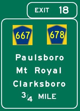
EXIT 18
Co. 678
East Greenwich Township
Mount Royal
Co. 667 North
Paulsboro
Co. 667 South
Clarksboro
East Greenwich Township
|
|
EXIT 18
Directions
EAST GREENWICH TOWNSHIP
Death of the Fox Brewery, 3/4 mile SE
|
|
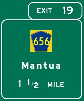
EXIT 19
Mantua Township
West Deptford Township
|
|
|
|
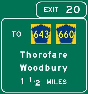
EXIT 20
Thorofare
West Deptford Township
Woodbury
|
|
|
|
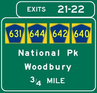
EXIT 21
National Park
West Deptford Township
Woodbury
EXIT 22
Red Bank (Gloucester County)
West Deptford Township
Woodbury
|
|
EXIT 21
Directions
DEPTFORD
Museum of American History, 3 3/4 miles NE
NATIONAL PARK
Red Bank Battlefield/James and Ann Whitall House,
2 1/4 miles NW
WOODBURY
Hunter-Lawrence-Jessup House, 1 1/2 miles east
|
|
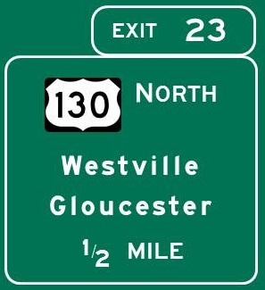
EXIT 23
Brooklawn
Gloucester City
Westville
|
Continue north on
|
EXIT 23
Directions
GLOUCESTER CITY
Gloucester City Historical Society, 3 1/4 miles north
WESTVILLE
Westville Brewing Co., 1 1/2 miles NE
WOODBURY
Eight & Sand Brewing Co., 1 mile SE
Striped Lion Distilling, 1 mile south
|
|
EXIT 26
I-76 Express
Philadelphia - South Phila/
West Phila/Stadiums/
Schuylkill Expressway
University of Pennsylvania
Walt Whitman Bridge
I-76 Local or Express to I-676
Ben Franklin Bridge
Camden
Philadelphia - Center City/
Historic District
Riverfront Stadium
Rutgers University -
South Jersey
Susquehanna Bank Center
Temple University
I-76 Local
Collingswood
Gloucester City
Mount Ephraim
|
I-76 Express I-76 Local
Continue west on 
|
EXIT 26
Directions
CAMDEN
Adventure Aquarium, 6 miles north
Camden County Historical Society Museum,
4 1/2 miles north
Camden Shipyard and Maritime Museum,
3 3/4 miles north
Rutgers-Camden Ctr for the Arts/Stedman Art Gallery,
6 miles north
South Camden Theatre Co., 3 1/2 miles north
USS New Jersey Battleship Museum, 6 miles north
Walt Whitman House State Historic Site,
5 1/2 miles north
COLLINGSWOOD
Perkins Center for the Arts, 3 3/4 miles NE
Scottish Rite Auditorium, 3 1/4 miles NE
|
|
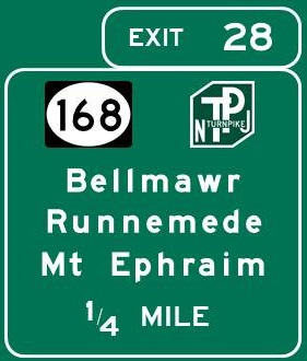
EXIT 28
NJ 168 North
Audubon Park
Haddon Heights
Mount Ephraim
NJ 168 South
Bellmawr
Runnemede
New Jersey Turnpike
|
Continue north / south on 
|
EXIT 28
Directions
OAKLYN
Tonewood Brewing, 3 miles north
|
|
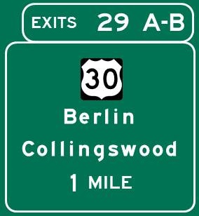
EXIT 29A
Berlin
Clementon
Laurel Springs
Lawnside
Lindenwold
Magnolia
Somerdale
Stratford
EXIT 29B
Audubon
Barrington
Collingswood
Haddon Heights
Haddonfield
Oaklyn
|
Continue east / west on 
|
EXIT 29A
Directions
BERLIN
Berlin Brewing Co., 9 miles SE
CLEMENTON
Clementon Park and Splash World,
6 miles SE
LAWNSIDE
Peter Mott House, 1 mile SE
SOMERDALE
Armageddon Brewing Co., 2 miles SE
Flying Fish Brewery, 2 miles SE
VOORHEES
Gravity Vault, 3 miles SE
EXIT 29B
Directions
AUDUBON
Red White and Brew Beer Co., 2 miles NW
HADDON HEIGHTS
Tanner Brewing Co., 1 mile NW
HADDON TOWNSHIP
Ritz Theatre Company, 2 1/2 miles NW
HADDONFIELD
Greenfield Hall, 2 1/4 miles NE
Haddonfield Plays and Players, 1 3/4 miles NE
Indian King State Historic Site, 2 miles NE
King's Road Brewing Co., 2 miles NE
Markeim Arts Center, 3 miles NE
|
|
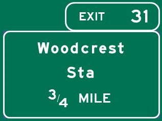
EXIT 31
Woodcrest Station
Patco Line
|
|
|
|
EXIT 32
Co. 561 East
Berlin
Gibbsboro
Voorhees Township
Voorhees Town Center
Co. 561 West
Haddon Township
Haddonfield
|

|
EXIT 32
Directions
BERLIN
Big Kahuna's, 7 1/2 miles SE
Diggerland, 7 3/4 miles SE
CHERRY HILL
Chopper's Hatchet House, 1/4 mile SE
EVESHAM TOWNSHIP
Black Run Preserve, 7 1/4 miles east
|
|
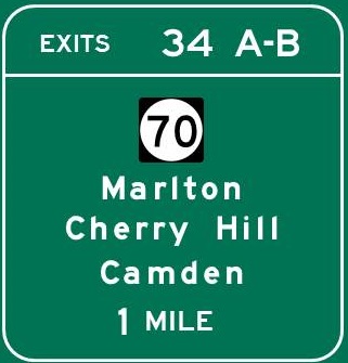
EXIT 34A
Lakehurst
Long Beach Island
Marlton
Medford
Point Pleasant
Whiting
Joint Base MDL
Lakehurst Naval Air Station
EXIT 34B
Camden
Cherry Hill
Cherry Hill Mall
|
Continue east / west on 
|
EXIT 34A
Directions
CHERRY HILL
Bury the Hatchet, 1 mile east
Escape Virtual Reality, 2 1/4 miles east
Forgotten Boardwalk Brewing, 1 1/4 miles NE
Mechanical Brewery, 1 mile south
MARLTON
Center for the Arts in Southern New Jersey,
6 1/4 miles SE
MEDFORD
Medford Arts Center, 9 miles east
Dr. James Still Historic Office Site, 9 1/2 miles east
Woodford Cedar Run Wildlife Refuge, 11 miles SE
EXIT 34B
Directions
CHERRY HILL
Barclay Farmstead, 1 1/4 miles SW
The Big Event, 1 3/4 miles west
Sector X, 3 1/2 miles west
MERCHANTVILLE
Eclipse Brewing Co., 6 miles NW
|
|
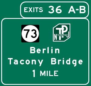
EXIT 36A
Berlin
Evesham Township
Marlton
Mount Laurel
New Jersey Turnpike
EXIT 36B
Cinnaminson
Maple Shade
Palmyra
Philadelphia PA -
Bridesburg/Frankford/
Port Richmond
via Betsy Ross Bridge
Philadelphia PA -
Holmesburg/Tacony/
Torresdale
via Tacony-Palmyra Bridge
Riverton
Moorestown Mall
|
Continue north / south on 
|
EXIT 36A
Directions
CHERRY HILL
MOUNT LAUREL
Coco Key Water Resort, 3/4 mile north
EXIT 36B
Directions
CINNAMINSON
K1 Speed, 6 3/4 miles north
MAPLE SHADE
Elite Climbing, 2 1/4 miles NW
Sky Zone Trampoline Park, 3/4 mile NW
MOORESTOWN
Family Virtual Fun Zone, 1 mile north
Perkins Center for the Arts, 3 1/2 miles NE
Smith-Cadbury Mansion, 4 miles NE
PALMYRA
Palmyra Cove Nature Park, 7 miles NW
PENNSAUKEN
Double Nickel Brewing Co., 5 1/4 miles NW
|
|
EXIT 40A
Hainesport
Mount Holly
Pemberton
Burlington County College -
Mount Laurel Campus
Virtua Memorial Hospital
EXIT 40B
Moorestown
Centerton Square Mall
|

Continue east / west on 
|
EXIT 40A
Directions
EASTAMPTON
Smithville Mansion, 9 1/2 miles east
Underground Railroad Museum of New Jersey,
9 1/2 miles east
Worker's House and Gallery, 9 1/2 miles east
LUMBERTON
Air Victory Museum, 5 miles SE
MOUNT LAUREL
The Funplex, 1 1/4 miles NE
EXIT 40B
Directions
MOUNT LAUREL
Paulsdale, 1 3/4 miles SW
|
|
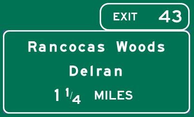
EXIT 43
Bridgeboro
Delran Township
Hainesport
Rancocas Woods
Riverside
|
|
EXIT 43
Directions
DELRAN
Funzilla, 5 1/2 miles NW
HAINESPORT
Rancocas State Park
Deacon Rd. entrance, 3 3/4 miles east
Rancocas Ave. entrance, 3 1/2 miles east
MOORESTOWN
Boundary Creek Natural Resource Area, 2 miles NW
MOUNT HOLLY
Spellbound Brewing, 4 1/2 miles east
RIVERSIDE
Riverside Historical Society, 5 1/2 miles NW
|
|
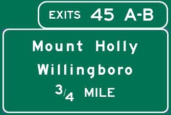
EXIT 45A
Mount Holly
Westampton Township
EXIT 45B
Beverly
Edgewater Park
Rancocas
Willingboro
Beverly National Cemetery
|
|
EXIT 45A
Directions
MOUNT HOLLY
Burlington Co Lyceum of History and Natural Sciences,
3 3/4 miles east
Burlington County Prison-Museum, 3 1/2 miles east
Train Wreck Distillery, 3 1/2 miles SE
Village Idiot Brewing Company, 4 miles east
Warden's House Gallery, 3 1/2 miles east
WESTAMPTON
 Rancocas Nature Center, 1 1/2 miles east Rancocas Nature Center, 1 1/2 miles east
Rancocas State Park
Rancocas Rd. entrance, 1 1/2 miles east
|
|
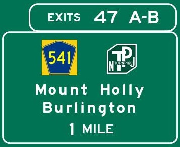
EXIT 47A
Mount Holly
Westampton Township
Burlington Center Mall
New Jersey Turnpike
EXIT 47B
Bristol PA
Burlington
Burlington-Bristol Bridge
|
|
EXIT 47B
Directions
BURLINGTON
Burlington County Historical Society, 2 1/2 miles NW
Lyceum Hall Center for the Arts, 2 1/2 miles NW
Third State Brewing, 2 3/4 miles NW
|
|
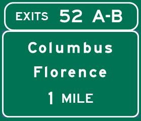
EXIT 52A
Columbus
Mansfield Township
Columbus Farmers Market
EXIT 52B
Florence
Roebling
|
|
EXIT 52A
Directions
MANSFIELD TOWNSHIP
Iron Plow Vineyards, 4 1/2 miles east
PLUMSTED TOWNSHIP
Laurita Winery, 14 1/2 miles east
SPRINGFIELD TOWNSHIP
Howlers Hatchet House, 4 miles SE
Recklesstown Farm Distillery, 4 3/4 miles SE
EXIT 52B
Directions
FLORENCE
Roebling Museum, 3 miles north
|
|
EXIT 56
Rising Sun Rd. West
Fieldsboro
Rising Sun Rd. East
Mansfield Township
via US 206 South
Wrightstown
via US 206/NJ 68 South
Joint Base MDL
via US 206/NJ 68 South
Fort Dix
McGuire AFB
New Jersey Turnpike
|

Continue north / south on 
|
|
|
EXIT 57
Bordentown
Chesterfield Township
|

Continue north on
Continue north on
|
EXIT 57
Directions
BORDENTOWN
Abbott Marshlands,
Bordentown Beach, 2 miles NW
Bordentown Bluffs, 2 1/2 miles north
Northern Community Park, 3 1/4 miles NE
Pegasus Theatre Company, 1 mile north
CHESTERFIELD
Fernbrook Farms Environmental Education Center,
3 1/4 miles SE
Fundaes Arcade, 3 1/2 miles east
|
|
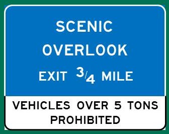
Scenic Overlook -
Milepost 58.0
|
|
HAMILTON
Abbott Marshlands,
D&R Canal Paths, accessible from overlook
|
|
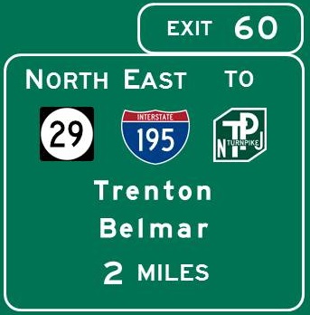
EXIT 60
NJ 29 North
Frenchtown
Lambertville
Trenton - Capitol District/
Downtown/Mill Hill/
South Trenton
Arm & Hammer Park
I-195 East
Allentown
Asbury Park
Belmar
Jackson Township
Lakewood
New Jersey Turnpike
|
Continue east on 
Continue north on 
|
EXIT 60
Directions
HAMILTON
Abbott Marshlands,
Duck Creek and D&R Canal Path, 4 miles south
JACKSON
Six Flags Great Adventure, 17 miles east
TRENTON
Artworks, 3 3/4 miles NW
Ellarslie, 5 1/2 miles NW
Meredith Havens Fire Museum, 4 1/4 miles NW
New Jersey State House, 4 miles NW
New Jersey State Museum, 4 miles NW
Old Barracks Museum, 4 miles NW
Passage Theatre Company, 4 miles NW
William Trent House, 3 1/4 miles NW
WEST TRENTON
New Jersey State Police Museum, 8 3/4 miles NW
|
|
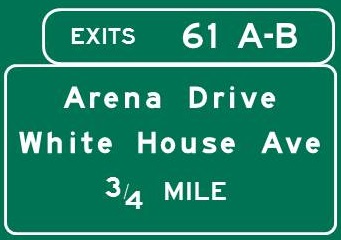
EXIT 61A
Hamilton Township -
White Horse/Yardville
EXIT 61B
Trenton - Villa Park/Wilbur
|
|
EXIT 61A
Directions
HAMILTON
Abbott Marshlands,
Nature Center/Roebling Park - Watson's Woods,
1 1/2 miles SW
Roebling Park - Spring Lake, 1 3/4 miles SW
Civil War and Native American Museum, 2 miles NE
EXIT 61B
Directions
HAMILTON
Kuser Farm Park, 1 1/4 miles NW
|
|
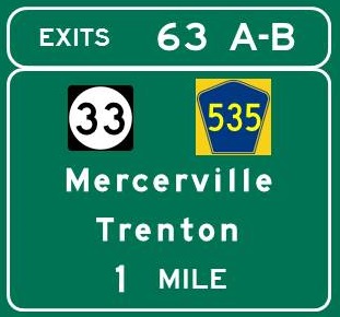
EXIT 63A
East Windsor Township
Freehold
Hamilton Township -
Hamilton Square/Mercerville
Hightstown
Robert Wood Johnson
University Hospital
EXIT 63B
Trenton - Downtown/
East Trenton/Mill Hill/Wilbur
|
Continue east / west on 
|
EXIT 63A
Directions
HAMILTON
Sayen Gardens, 2 1/2 miles east
WEST WINDSOR
Kelsey Theatre at Mercer, 2 3/4 miles NE
EXIT 63B
Directions
HAMILTON
Grounds for Sculpture, 1 1/2 miles west
Rockville Climbing Center, 2 miles NW
|
|
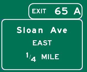
EXIT 65A
Hamilton Township
Mercer County Comm Coll
|
|
|
|
EXIT 65B
Hamilton Transit Center
NJTransit Rail
Trenton
|

|
EXIT 65A
Directions
HAMILTON
Sky Zone Trampoline Park, 1 mile NE
|
|
EXIT 67A
Elizabeth
New Brunswick
Newark
Quaker Bridge Mall
Rutgers University
EXIT 67B
Trenton
|

Continue north / south on 
|
EXIT 67A
Directions
FRANKLIN TOWNSHIP/SOUTH BRUNSWICK TOWNSHIP
Delaware and Raritan Canal State Park,
Cook Natural Area, 8 1/2 miles NE
Rocky Hill Access, 10 1/2 miles NE
Griggstown Access, 13 3/4 miles NE
Blackwells Mills Access, 17 1/2 miles NE
East Millstone Access, 19 1/2 miles NE
PRINCETON
Herrontown Woods, 8 miles NE
McCarter Theatre Center, 5 miles NE
Princeton University Art Museum, 6 1/2 miles NE
Updike Farmstead, 3 1/4 miles north
WEST WINDSOR
Stumpy's Hatchet House, 4 1/2 miles NE
EXIT 67B
Directions
LAWRENCE TOWNSHIP
Bury the Hatchet, 2 3/4 miles SW
|
|
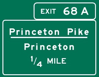
EXIT 68A
Lawrence Township
Princeton
|
|
EXIT 68A
Directions
PRINCETON
Institute Woods, 3 1/2 miles NE
Princeton Battlefield State Park, 3 1/2 miles NE
|
|
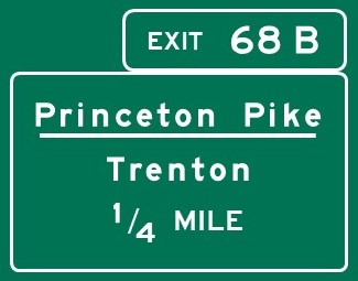
Exit 68B
Lawrence Township
Trenton
|
|
|
|
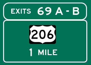
EXIT 69A
US 206 North
Lawrence Township
Lawrenceville
Princeton
EXIT 69B
US 206 South
Lawrence Township
Trenton
Rider University
|
Continue north / south on
|
EXIT 69A
Directions
HOPEWELL TOWNSHIP/LAWRENCE TOWNSHIP
Mercer Meadows
Curlis Woods, Education Center, Equestrian Center,
3 3/4 miles NW
Farm History District, 2 1/2 miles NW
Pole Farm District, 2 1/2 miles north
Rosedale Park, 3 1/2 miles NW
LAWRENCE TOWNSHIP
Terhune Orchards Vineyard and Winery, 4 miles north
PRINCETON
Morven Museum and Garden, 5 3/4 miles NE
EXIT 69B
Directions
LAWRENCE TOWNSHIP
National Guard Militia Museum of New Jersey,
1 3/4 miles SW
|
|
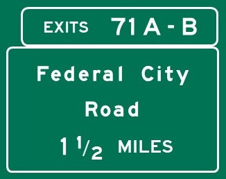
EXIT 71A
Lawrence Township
EXIT 71B
Ewing Township
|
|
EXIT 71B
Directions
EWING TOWNSHIP
Benjamin Temple House Museum, 1 mile SW
|
|
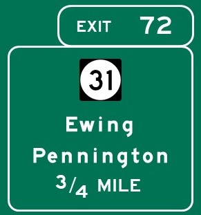
EXIT 72
NJ 31 North
Clinton
Flemington
Hopewell Borough
Hopewell Township
Pennington
NJ 31 South
Ewing Township
Trenton
The College of New Jersey
|
Continue north / south on 
|
EXIT 72
Directions
EWING TOWNSHIP
River Horse Brewing Co., 2 miles SW
TCNJ Art Gallery, 1 1/2 miles south
HOPEWELL
Hopewell Museum, 8 miles north
Hopewell Theater, 8 miles north
HOPEWELL TOWNSHIP
Hopewell Valley Vineyards, 4 1/2 miles north
The Watershed Institute, 6 miles north
WEST AMWELL
Pine Creek Miniature Golf, 8 3/4 miles north
|
|
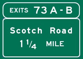
EXIT 73A
Hopewell Township
Capital Health Medical Ctr Hopewell
EXIT 73B
Ewing Township
Trenton-Mercer Airport/
General Aviation
|
|
EXIT 73A
Directions
HOPEWELL TOWNSHIP
Baldpate Mountain
Pleasant Valley Rd. access, 6 1/4 miles NE
|
|
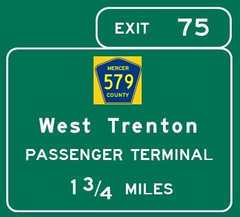
EXIT 75
Co. 579 North
Harbourton
Hopewell Township
Co. 579 South
Ewing Township
West Trenton
Trenton-Mercer Airport/
Passenger Terminal
|
|
|
|
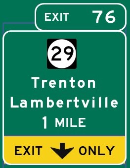
EXIT 76
NJ 29 North
Frenchtown
Hopewell Township
Lambertville
Stockton
Mercer County
Correctional Center
NJ 29 South
Ewing Township
Trenton -
Capitol Complex/Downtown
Arm & Hammer Park
New Jersey State Prison
St. Francis Medical Center
Sun National Bank Center
|
Continue north / south on
|
EXIT 76
Directions
HOPEWELL TOWNSHIP
Baldpate Mountain
Fiddlers Creek Rd. access, 5 1/2 miles NW
Howell Living History Farm, 8 1/2 miles NW
Washington Crossing State Park, 3 miles north
LAMBERTVILLE
Holcombe-Jimison Farmstead, 10 3/4 miles NW
James Wilson Marshall House, 9 1/2 miles NW
TRENTON
Artworks, 6 miles SE
Ellarslie, 4 miles SE
New Jersey State House, 5 miles SE
New Jersey State Museum, 5 miles SE
Old Barracks Museum, 5 miles SE
Passage Theatre Company, 6 1/4 miles SE
William Trent House, 5 3/4 miles SE
WEST AMWELL
Music Mountain Theatre, 10 3/4 miles NW
WEST TRENTON
New Jersey State Police Museum, 1 1/4 miles north
|
|
|
Home
|
|
